Mineral, Ohio
Unincorporated community in Ohio, U.S.
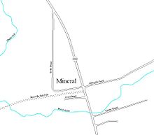
Mineral is an unincorporated community in Athens County, Ohio, United States.[1] Centered on State Route 356, it was established as a coal mining community. It is located on Mud Lick Run, which flows into nearby Hewitt Fork, a tributary of Raccoon Creek. The B&O Railroad once ran through the community, but was abandoned in the 1980s. In recent years, the portion of the old railroad grade going west from the community has become the Moonville Rail-Trail. The King Switch Tunnel on the grade is close to the community. The next larger community is New Marshfield, also unincorporated, to the east in the same township.[citation needed]
References
- ^ U.S. Geological Survey Geographic Names Information System: Mineral, Ohio
- v
- t
- e
Municipalities and communities of Athens County, Ohio, United States
County seat: Athens
- Athens
- Nelsonville

- Albany
- Amesville
- Buchtel‡
- Chauncey
- Coolville
- Glouster
- Jacksonville
- Trimble
communities
‡This populated place also has portions in an adjacent county or counties
- Ohio portal
- United States portal
39°19′26″N 82°15′53″W / 39.32389°N 82.26472°W / 39.32389; -82.26472
 | This Athens County, Ohio state location article is a stub. You can help Wikipedia by expanding it. |
- v
- t
- e


