Maputaland-Pondoland-Albany Hotspot

Southern Africa biodiversity hotspot

Maputaland-Pondoland-Albany Hotspot

The Maputaland-Pondoland-Albany Hotspot (MPA) is a biodiversity hotspot, a biogeographic region with significant levels of biodiversity, in Southern Africa. It is situated near the south-eastern coast of Africa, occupying an area between the Great Escarpment and the Indian Ocean.[1] The area is named after Maputaland, Pondoland and Albany. It stretches from the Albany Centre of Plant Endemism in the Eastern Cape Province of South Africa, through the Pondoland Centre of Plant Endemism and KwaZulu-Natal Province, the eastern side of Eswatini (known as Swaziland until 2018) and into southern Mozambique and Mpumalanga. The Maputaland Centre of Plant Endemism is contained in northern KwaZulu-Natal and southern Mozambique.

Geography

This ecoregion covers globally all the humid subtropical climate zones of Africa (the latter being located almost exclusively in South Africa), an area of 274,136 km2 (105,845 sq mi). It forms a broad coastal strip extending from the extreme south of Mozambique and north-east of Mpumalanga to the east of Eastern Cape Province in South Africa, including the Wild Coast. It also includes eastern Swaziland and borders southern and eastern Lesotho. It consists of three regions more or less biologically close but each with its own characteristics. Maputaland (also known as Tongaland) refers to the southern part of Mozambique, Swaziland and northern KwaZulu-Natal, Pondoland includes central and southern KwaZulu-Natal, and Albany is the eastern part of Eastern Cape.[2]

The terrain in this region is complex, providing a great diversity of landscapes with varied reliefs. It encompasses the southeast of the Great Escarpment and down to the edge of the Indian Ocean. As a result, this ecoregion includes much of the Drakensberg range, especially in the south and centre of the area. One of the best-watered areas in South Africa, a large part of the area receives on average between 750 and 1,000 mm (30 and 39 in) per year and the Kwazulu-Natal coasts as well as parts of the Drakensberg exceed the annual 1,000 mm (39 in).[3] The northern part of the area consists mainly of medium and lowland plains with areas of ancient sand dunes, while the southern part has more rugged terrain with many cliffs cut by multiple streams. Inland, there are several ranges of mountain which include Sneeuberge, Winterberg, Amathole Mountains, Ngeli Range, Lebombo Mountains and Ngoye Range.[4]

Landscapes of Maputaland-Pondoland-Albany, from left to right: shrubby grassland near Pietermaritzburg; dense forest in KwaZulu-Natal; wooded savanna with Strelitzia nicolai in iSimangaliso Wetland Park; high altitude grassland near Ladysmith; shrubby savanna with tree spurge in the north of Kwazulu-Natal; coastal scrub and forest in Silaka Nature Reserve

Biodiversity

The Maputaland-Pondoland-Albany area supports a very high biodiversity, both animal and plant. With nearly 8100 vascular plants species and 2000 endemic plant species, it is the second richest area in Africa in terms of plant diversity, after the Cape Floristic Region. The Albany region also has a great diversity of succulent plants, notably arborescent plants, differing from the leafy succulent species of the Karoo desert. The vegetation cover is mainly composed of forests, shrubland, bushveld and meadows. About 80% of the remaining forests of South Africa occur in this region, and nearly 600 species of trees are represented here, the highest diversity of any temperate forest in the world. Among the large number of plants in this ecoregion, about 1900 are endemic.[4] There is also an endemic family, that of Rhynchocalycaceae, which has only one species: Rhynchocalyx lawsonioides. Many plants present in this hotspot were subsequently widely used as ornamental or medicinal plants; examples include Strelitzia reginae and nicolai, Clivia miniata, Kniphofia or the extremely rare Sandersonia aurantiaca. Aloe ferox is widely used for its sap with healing properties.

Although the hotspot was originally envisaged as referring to the wide diversity of vascular plant species, the pattern of plant endemism is matched by numerous endemic vertebrates. The degree of endemism among plants in this hotspot is 23.5% whereas the degree of endemism among vertebrates is 5.1% and near-endemism 4.9%. If the area of the hotspot was redefined as the "Greater Maputaland-Pondoland-Albany" area, an increase of 73%, to include the Great Escarpment area, the vertebrate endemism would total 146 species (19 freshwater fishes, 29 amphibians, 75 reptiles, 15 birds and 8 mammals), a figure 135% higher than the 62 vertebrate species for the MPA as presently defined.[5]

Most of the endemic vertebrates in the ecoregion inhabit the forests and grasslands, and many have niche habitat requirements such as rocky outcrops or marshy areas within these larger biomes; the Sloggett's vlei rat and the Natal red rock hare are quite widespread in the area while the woodbush legless skink and the robust golden mole have narrower habitat requirements.[6]

A White Rhino emerging from a mud bath in Hluhluwe-Umfolozi Reserve

Animal diversity is lower, with fairly low endemism. 194 species of mammals are counted there, of which only 4 are endemic: Red bush squirrel (Paraxerus palliates), four-toed elephant shrew (Petrodromus tetradactylus), narrow-headed golden mole (Amblysomus marleyi) and the giant golden mole (Chrysospalax trevelyani). However, there are many notable species: antelopes, felines, primates, rhinos, which are not endemic but very representative of protected areas, particularly in Maputaland.[7] This is particularly the case of the southern subspecies of the White rhinoceros (Ceratotherium simum simum) which was once widely distributed in southern and eastern Africa and which almost disappeared due to the horn trade; yet it is with a dozen individuals placed in the Hluhluwe–Imfolozi Park that the population experienced an extraordinary surge: today it has nearly 12,000 individuals spread over several reserves including outside South Africa. There are also several species of forest antelope such as the Zanzibar Suni (Neotragus moschatus) or the blue duiker (Philantomba monticola).

There are 540 bird species in this hotspot. If none is endemic, it appears that many southern African forest species are present in this region, and that some are almost endemic to this hotspot, such as the Cape parrot for example. Others are found only in this region in South Africa but their distribution extends beyond into the coastal forests of eastern Africa.[8]

Of 209 species of reptiles 30 are endemic. This hotspot is the home of at least 7 species of dwarf chameleons of the genus Bradypodion whose distribution is very small. There is also an endemic genus containing a single species: the Natal black snake (Macrelaps microlepidotus). Other endemic species include the Natal hinge-back tortoise (Kinixys natalensis), a turtle unique to the Lembobo Mountains, the very rare Albany viper (Bitis albanica) confined to Algoa Bay (Eastern Cape), and a species of lizard: the Tasman's cordyle (Cordylus tasmani). There are also 72 species of amphibians, 11 of which are unique to this region, including an endemic monospecific genus including the Boneberg frog (Natalobatrachus bonebergi). There are other endangered species: Hogsback frog (Anhydrophryne rattrayi), Afrixalus spinifrons, Hyperolius pickersgilli, as well as a recently discovered species, Breviceps sopranus, which emits a very high-pitched croak.

Among the other groups of the animal kingdom we can note the 73 species of freshwater fish with 22 endemic. A species of shark, the Paragaleus leucolomatus, is only known from a single specimen caught in Kosi Bay (natural reserve, coord. -26.895129,32.825546) south of Maputo. Among the species of invertebrates we find in particular the very primitive Onychophora, which resemble worms with legs and velvety skin. In the moist forest floors lives a species of giant earthworm (Microchaetus vernoni) that can reach 2.6m in length. There is also a species of flightless dung beetle: Circellium bacchus, whose range is concentrated only in the Addo Elephant National Park (where specific signs indicate that it has priority over vehicles in the thoroughfares)[9] and surrounding areas.[10]

From left to right: Strelitzia reginae, Leptopelis natalensis, Euphorbia cooperi, Blue duiker (Philantomba monticola), Kniphofia rooperi, Aloe ferox, Knysna loerie (Tauraco corythaix), Onychophora sp, Hibiscus pedunculatus

List of endemic plants (incomplete)

The endemic plants found in the Maputaland-Pondoland-Albany Hotspot
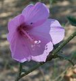
 include:[11]

Gallery

See also

References

  1. ^ Biodiversity Archived 2010-03-23 at the Wayback Machine
  2. ^ Philip's (1994). Atlas of the World. Reed International. pp. 104–105. ISBN 0-540-05831-9.
  3. ^ "CEPF Final Project Completion Report" (PDF). Critical Ecosystem Partnership Fund. July 1, 2016. Retrieved July 6, 2019.
  4. ^ a b "Maputaland-Pondoland-Albany". Biodiversity hotspots. Conservation International. Archived from the original on March 23, 2010. Retrieved July 6, 2019.
  5. ^ Perera, Sandun J.; Ratnayake-Perera, Dayani; Procheş. Şerban (2011). "Vertebrate distributions indicate a greater Maputaland-Pondoland-Albany region of endemism". South African Journal of Science. 107 (7–8). doi:10.4102/sajs.v107i7/8.462.
  6. ^ Perera, Sandun J. (2011). "Veretbrate distributions indicate a greater Maputaland-Pondoland-Albany region of endemism". South African Journal of Science. Retrieved July 6, 2019.
  7. ^ Stuart, Chris; Stuart, Tilde (2007). Field guide to mammals of southern Africa (4 ed.). Cape Town: Struik. ISBN 978-1-77007-404-0.
  8. ^ Sinclair, Ian; Arlott, Norman; Hayman, Peter; Sasol Industries, eds. (2011). Sasol birds of southern Africa: the region's most comprehensively illustrated guide (4th ed., fully rev. and updated ed.). Cape Town: Struik Nature. ISBN 978-1-77007-925-0.
  9. ^ Gouyou Beauchamps, Pierre (January–February 2012). "Wild Coast - Les bijoux de la Côte Sauvage". Terre sauvage (in French). No. 1201. pp. 70–79. Caution : Dung beetles have right of way
  10. ^ "Maputaland-Pondoland-Albany | CEPF". www.cepf.net. Retrieved May 29, 2023.
  11. ^ Van Wyk, A.E.; Smith, G.F. (2001). Regions of floristic endemism in southern Africa. Umdaus Press. pp. 82–109. ISBN 978-1-919766-18-8.

Bibliography

  • Pooley, E. (1993). The Complete Field Guide to Trees of Natal, Zululand and Transkei. ISBN 0-620-17697-0.
  • Pooley, E. (1998). A Field Guide to Wild Flowers; KwaZulu-Natal and the Eastern Region. ISBN 0-620-21500-3.

External links

  • Conservation International
  • Maputaland-Pondoland-Albany Hotspot
  • v
  • t
  • e
National taxon checklists
Plants
Flowering
plants
Animals
Arthropods
Arachnids
  • Harvestmen
  • Microwhip scorpions
  • Pseudoscorpions
  • Scorpions
  • Shorttailed whipscorpions
  • Solifugae
  • Araneae
  • Ixodida
  • Whip spiders and tailless whip scorpions
Insects
  • Alderflies, dobsonflies and fishflies
  • Beetles
  • Booklice, barklice and barkflies
  • Butterflies and moths
  • Caddisflies
  • Cockroaches and termites
  • Dragonflies and damselflies
  • Earwigs
  • Fleas
  • Flies
  • Jumping bristletails
  • Lice
  • Mantises
  • Mayflies
  • Net-winged insects
  • Notoptera
  • Orthoptera
  • Sawflies, wasps, bees, and ants
  • Scorpionflies
  • Silverfish and firebrats
  • Stick and leaf insects
  • Stoneflies
  • Strepsiptera
  • Termites
  • Thrips
  • True bugs
  • Webspinners
Molluscs
Vertebrates
Seaweeds
Fungi
Related
Regional taxon checklists and other minor lists
Tropical and subtropical
moist broadleaf forests
Tropical and subtropical grasslands,
savannas, and shrublands
Montane grasslands
and shrublands
Mediterranean forests,
woodlands, and scrub
Deserts and xeric shrublands
Tundra
Mangroves
Marine ecoregions
Savanna
  • Andesite Mountain Bushveld
  • Aoub Duneveld
  • Barberton Serpentine Sourveld
  • Bhisho Thornveld
  • Cathedral Mopane Bushveld
  • Central Sandy Bushveld
  • Delagoa Lowveld
  • Dwaalboom Thornveld
  • Dwarsberg-Swartruggens Mountain Bushveld
  • Eastern Valley Bushveld
  • Gabbro Grassy Bushveld
  • Gauteng Shale Mountain Bushveld
  • Ghaap Plateau Vaalbosveld
  • Gold Reef Mountain Bushveld
  • Gordonia Duneveld
  • Gordonia Kameeldoring Bushveld
  • Gordonia Plains Shrubland
  • Granite Lowveld
  • Gravelotte Rocky Bushveld
  • Kaalrug Mountain Bushveld
  • Kathu Bushveld
  • Kimberley Thornveld
  • Koranna-Langeberg Mountain Bushveld
  • Kuruman Mountain Bushveld
  • Kuruman Thornveld
  • Kuruman Vaalbosveld
  • KwaZulu-Natal Hinterland Thornveld
  • KwaZulu-Natal Sandstone Sourveld
  • Lebombo Summit Sourveld
  • Legogote Sour Bushveld
  • Limpopo Ridge Bushveld
  • Limpopo Sweet Bushveld
  • Loskop Mountain Bushveld
  • Loskop Thornveld
  • Lowveld Rugged Mopaneveld
  • Madikwe Dolomite Bushveld
  • Mafikeng Bushveld
  • Makatini Clay Thicket
  • Makhado Sweet Bushveld
  • Makuleke Sandy Bushveld
  • Malelane Mountain Bushveld
  • Mamabolo Mountain Bushveld
  • Marikana Thornveld
  • Molopo Bushveld
  • Moot Plains Bushveld
  • Mopane Basalt Shrubland
  • Mopane Gabbro Shrubland
  • Musina Mopane Bushveld
  • Ngongoni Veld
  • Norite Koppies Bushveld
  • Northern Lebombo Bushveld
  • Northern Zululand Sourveld
  • Nossob Bushveld
  • Nwambyia-Pumbe Sandy Bushveld
  • Ohrigstad Mountain Bushveld
  • Olifantshoek Plains Thornveld
  • Phalaborwa-Timbavati Mopaneveld
  • Pilanesberg Mountain Bushveld
  • Polokwane Plateau Bushveld
  • Postmasburg Thornveld
  • Poung Dolomite Mountain Bushveld
  • Pretoriuskop Sour Bushveld
  • Roodeberg Bushveld
  • Schmidtsdrif Thornveld
  • Schweizer-Reneke Bushveld
  • Sekhukhune Mountain Bushveld
  • Sekhukhune Plains Bushveld
  • South Eastern Coastal Thornveld
  • Southern Lebombo Bushveld
  • Soutpansberg Mountain Bushveld
  • Springbokvlakte Thornveld
  • Stella Bushveld
  • Swaziland Sour Bushveld
  • Tembe Sandy Bushveld
  • Thukela Thornveld
  • Thukela Valley Bushveld
  • Tsende Mopaneveld
  • Tshokwane-Hlane Basalt Lowveld
  • Tzaneen Sour Bushveld
  • Vaalbos Rocky Shrubland
  • VhaVenda Miombo
  • Waterberg Mountain Bushveld
  • Western Maputaland Clay Bushveld
  • Western Maputaland Sandy Bushveld
  • Western Sandy Bushveld
  • Zeerust Thornveld
  • Zululand Coastal Thornveld
  • Zululand Lowveld
Grassland
  • Aliwal North Dry Grassland
  • Amathole Mistbelt Grassland
  • Amathole Montane Grassland
  • Amersfoort Highveld Clay Grassland
  • Barberton Montane Grassland
  • Basotho Montane Shrubland
  • Bedford Dry Grassland
  • Besemkaree Koppies Shrubland
  • Bloemfontein Dry Grassland
  • Bloemfontein Karroid Shrubland
  • Carletonville Dolomite Grassland
  • Central Free State Grassland
  • Drakensberg Afroalpine Heathland
  • Drakensberg Foothill Moist Grassland
  • Drakensberg-Amathole Afromontane Fynbos
  • East Griqualand Grassland
  • Eastern Free State Clay Grassland
  • Eastern Free State Sandy Grassland
  • Eastern Highveld Grassland
  • Egoli Granite Grassland
  • Frankfort Highveld Grassland
  • Income Sandy Grassland
  • Ithala Quartzite Sourveld
  • KaNgwane Montane Grassland
  • Karoo Escarpment Grassland
  • Klerksdorp Thornveld
  • KwaZulu-Natal Highland Thornveld
  • Leolo Summit Sourveld
  • Lesotho Highland Basalt Grassland
  • Low Escarpment Moist Grassland
  • Lydenburg Montane Grassland
  • Lydenburg Thornveld
  • Mabela Sandy Grassland
  • Midlands Mistbelt Grassland
  • Mooi River Highland Grassland
  • Mthatha Moist Grassland
  • Northern Drakensberg Highland Grassland
  • Northern Escarpment Afromontane Fynbos
  • Northern Escarpment Dolomite Grassland
  • Northern Escarpment Quartzite Sourveld
  • Northern Free State Shrubland
  • Northern KwaZulu-Natal Moist Grassland
  • Northern KwaZulu-Natal Shrubland
  • Northern Zululand Mistbelt Grassland
  • Paulpietersburg Moist Grassland
  • Queenstown Thornveld
  • Rand Highveld Grassland
  • Sekhukhune Montane Grassland
  • Senqu Montane Shrubland
  • Southern Drakensberg Highland Grassland
  • Southern KwaZulu-Natal Moist Grassland
  • Soutpansberg Summit Sourveld
  • Soweto Highveld Grassland
  • Steenkampsberg Montane Grassland
  • Stormberg Plateau Grassland
  • Strydpoort Summit Sourveld
  • Tarkastad Montane Shrubland
  • Tsakane Clay Grassland
  • Tsomo Grassland
  • uKhahlamba Basalt Grassland
  • Vaal Reefs Dolomite Sinkhole Woodland
  • Vaal-Vet Sandy Grassland
  • Vredefort Dome Granite Grassland
  • Wakkerstroom Montane Grassland
  • Waterberg-Magaliesberg Summit Sourveld
  • Western Free State Clay Grassland
  • Western Highveld Sandy Grassland
  • Western Lesotho Basalt Shrubland
  • Winburg Grassy Shrubland
  • Wolkberg Dolomite Grassland
  • Woodbush Granite Grassland
  • Xhariep Karroid Grassland
  • Zastron Moist Grassland
Fynbos
  • Agulhas Limestone Fynbos
  • Agulhas Sand Fynbos
  • Albertinia Sand Fynbos
  • Algoa Sandstone Fynbos
  • Atlantis Sand Fynbos
  • Bokkeveld Sandstone Fynbos
  • Boland Granite Fynbos
  • Breede Alluvium Fynbos
  • Breede Quartzite Fynbos
  • Breede Sand Fynbos
  • Breede Shale Fynbos
  • Canca Limestone Fynbos
  • Cape Flats Sand Fynbos
  • Cape Winelands Shale Fynbos
  • Cederberg Sandstone Fynbos
  • Central Coastal Shale Band Vegetation
  • Central Inland Shale Band Vegetation
  • De Hoop Limestone Fynbos
  • Eastern Coastal Shale Band Vegetation
  • Eastern Inland Shale Band Vegetation
  • Elgin Shale Fynbos
  • Elim Ferricrete Fynbos
  • Garden Route Granite Fynbos
  • Garden Route Shale Fynbos
  • Graafwater Sandstone Fynbos
  • Greyton Shale Fynbos
  • Grootrivier Quartzite Fynbos
  • Hangklip Sand Fynbos
  • Hawequas Sandstone Fynbos
  • Hopefield Sand Fynbos
  • Kamiesberg Granite Fynbos
  • Kango Conglomerate Fynbos
  • Knysna Sand Fynbos
  • Kogelberg Sandstone Fynbos
  • Kouebokkeveld Alluvium Fynbos
  • Kouebokkeveld Shale Fynbos
  • Kouga Grassy Sandstone Fynbos
  • Kouga Sandstone Fynbos
  • Leipoldtville Sand Fynbos
  • Loerie Conglomerate Fynbos
  • Lourensford Alluvium Fynbos
  • Matjiesfontein Quartzite Fynbos
  • Matjiesfontein Shale Fynbos
  • Montagu Shale Fynbos
  • Namaqualand Sand Fynbos
  • North Hex Sandstone Fynbos
  • North Kammanassie Sandstone Fynbos
  • North Langeberg Sandstone Fynbos
  • North Outeniqua Sandstone Fynbos
  • North Rooiberg Sandstone Fynbos
  • North Sonderend Sandstone Fynbos
  • North Swartberg Sandstone Fynbos
  • Northern Inland Shale Band Vegetation
  • Olifants Sandstone Fynbos
  • Overberg Sandstone Fynbos
  • Peninsula Granite Fynbos
  • Peninsula Sandstone Fynbos
  • Piketberg Sandstone Fynbos
  • Potberg Ferricrete Fynbos
  • Potberg Sandstone Fynbos
  • Robertson Granite Fynbos
  • South Hex Sandstone Fynbos
  • South Kammanassie Sandstone Fynbos
  • South Langeberg Sandstone Fynbos
  • South Outeniqua Sandstone Fynbos
  • South Rooiberg Sandstone Fynbos
  • South Sonderend Sandstone Fynbos
  • South Swartberg Sandstone Fynbos
  • Southern Cape Dune Fynbos
  • Stinkfonteinberge Quartzite Fynbos
  • Suurberg Quartzite Fynbos
  • Suurberg Shale Fynbos
  • Swartberg Altimontane Sandstone Fynbos
  • Swartberg Shale Fynbos
  • Swartland Alluvium Fynbos
  • Swartruggens Quartzite Fynbos
  • Swellendam Silcrete Fynbos
  • Tsitsikamma Sandstone Fynbos
  • Western Altimontane Sandstone Fynbos
  • Western Coastal Shale Band Vegetation
  • Winterhoek Sandstone Fynbos
Renosterveld
  • Baviaanskloof Shale Renosterveld
  • Breede Alluvium Renosterveld
  • Breede Shale Renosterveld
  • Central Mountain Shale Renosterveld
  • Central Ruêns Shale Renosterveld
  • Ceres Shale Renosterveld
  • Eastern Ruêns Shale Renosterveld
  • Hantam Plateau Dolerite Renosterveld
  • Humansdorp Shale Renosterveld
  • Kango Limestone Renosterveld
  • Langkloof Shale Renosterveld
  • Matjiesfontein Shale Renosterveld
  • Montagu Shale Renosterveld
  • Mossel Bay Shale Renosterveld
  • Namaqualand Granite Renosterveld
  • Nieuwoudtville Shale Renosterveld
  • Nieuwoudtville-Roggeveld Dolerite Renosterveld
  • Peninsula Shale Renosterveld
  • Robertson Granite Renosterveld
  • Roggeveld Shale Renosterveld
  • Ruêns Silcrete Renosterveld
  • Swartberg Shale Renosterveld
  • Swartland Alluvium Renosterveld
  • Swartland Granite Renosterveld
  • Swartland Shale Renosterveld
  • Swartland Silcrete Renosterveld
  • Uniondale Shale Renosterveld
  • Vanrhynsdorp Shale Renosterveld
  • Western Ruêns Shale Renosterveld
Succulent
Karoo
  • Aggeneys Gravel Vygieveld
  • Agter-Sederberg Shrubland
  • Anenous Plateau Shrubland
  • Bushmanland Inselberg Shrubland
  • Central Knersvlakte Vygieveld
  • Central Richtersveld Mountain Shrubland
  • Citrusdal Vygieveld
  • Die Plate Succulent Shrubland
  • Doringrivier Quartzite Karoo
  • Eastern Little Karoo
  • Eenriet Plains Succulent Shrubland
  • Goariep Mountain Succulent Shrubland
  • Hantam Karoo
  • Kamiesberg Mountains Shrubland
  • Klawer Sandy Shrubland
  • Knersvlakte Dolomite Vygieveld
  • Knersvlakte Quartz Vygieveld
  • Knersvlakte Shale Vygieveld
  • Koedoesberge-Moordenaars Karoo
  • Kosiesberg Succulent Shrubland
  • Lekkersing Succulent Shrubland
  • Little Karoo Quartz Vygieveld
  • Namaqualand Arid Grassland
  • Namaqualand Blomveld
  • Namaqualand Coastal Duneveld
  • Namaqualand Heuweltjie Strandveld
  • Namaqualand Heuweltjieveld
  • Namaqualand Inland Duneveld
  • Namaqualand Klipkoppe Shrubland
  • Namaqualand Shale Shrubland
  • Namaqualand Spinescent Grassland
  • Namaqualand Strandveld
  • Northern Knersvlakte Vygieveld
  • Northern Richtersveld Scorpionstailveld
  • Northern Richtersveld Yellow Duneveld
  • Oograbies Plains Sandy Grassland
  • Piketberg Quartz Succulent Shrubland
  • Platbakkies Succulent Shrubland
  • Prince Albert Succulent Karoo
  • Richtersveld Coastal Duneveld
  • Richtersveld Red Duneveld
  • Richtersveld Sandy Coastal Scorpionstailveld
  • Riethuis-Wallekraal Quartz Vygieveld
  • Robertson Karoo
  • Roggeveld Karoo
  • Rooiberg Quartz Vygieveld
  • Rosyntjieberg Succulent Shrubland
  • Southern Namaqualand Quartzite Klipkoppe Shrubland
  • Southern Richtersveld Inselberg Shrubland
  • Southern Richtersveld Scorpionstailveld
  • Southern Richtersveld Yellow Duneveld
  • Steytlerville Karoo
  • Stinkfonteinberge Eastern Apron Shrubland
  • Swartruggens Quartzite Karoo
  • Tanqua Escarpment Shrubland
  • Tanqua Karoo
  • Tatasberg Mountain Succulent Shrubland
  • Umdaus Mountains Succulent Shrubland
  • Upper Annisvlakte Succulent Shrubland
  • Vanrhynsdorp Gannabosveld
  • Vyftienmyl se Berge Succulent Shrubland
  • Western Bushmanland Klipveld
  • Western Gwarrieveld
  • Western Little Karoo
  • Willowmore Gwarrieveld
Albany
Thicket
and
Strandveld
  • Albany Arid Thicket
  • Albany Bontveld
  • Albany Mesic Thicket
  • Albany Valley Thicket
  • Baviaans Valley Thicket
  • Bethelsdorp Bontveld
  • Blombos Strandveld
  • Buffels Mesic Thicket
  • Buffels Valley Thicket
  • Cape Flats Dune Strandveld
  • Crossroads Grassland Thicket
  • Doubledrift Karroid Thicket
  • Eastern Gwarrieveld
  • Elands Forest Thicket
  • Escarpment Arid Thicket
  • Escarpment Mesic Thicket
  • Escarpment Valley Thicket
  • Fish Arid Thicket
  • Fish Mesic Thicket
  • Fish Valley Thicket
  • Gamka Arid Thicket
  • Gamka Valley Thicket
  • Geluk Grassland Thicket
  • Goukamma Dune Thicket
  • Gouritz Valley Thicket
  • Grahamstown Grassland Thicket
  • Grassridge Bontveld
  • Groot Brak Dune Strandveld
  • Hamburg Dune Thicket
  • Hartenbos Dune Thicket
  • Kasouga Dune Thicket
  • Koedoeskloof Karroid Thicket
  • Lambert's Bay Strandveld
  • Langebaan Dune Strandveld
  • Mons Ruber Fynbos Thicket
  • Motherwell Karroid Thicket
  • Nanaga Savanna Thicket
  • Oudshoorn Karroid Thicket
  • Overberg Dune Strandveld
  • Saldanha Flats Strandveld
  • Saldanha Granite Strandveld
  • Saldanha Limestone Strandveld
  • Saltaire Karroid Thicket
  • Sardinia Forest Thicket
  • St Francis Dune Thicket
  • Subtropical Dune Thicket
  • Sundays Arid Thicket
  • Sundays Mesic Thicket
  • Sundays Valley Thicket
  • Thorndale Forest Thicket
  • Umtiza Forest Thicket
  • Vanstadens Forest Thicket
  • Western Gwarrieveld
  • Willowmore Gwarrieveld
Nama
Karoo
and
desert
  • Albany Broken Veld
  • Blouputs Karroid Thornveld
  • Bushmanland Arid Grassland
  • Bushmanland Basin Shrubland
  • Bushmanland Sandy Grassland
  • Eastern Lower Karoo
  • Eastern Upper Karoo
  • Gamka Karoo
  • Kalahari Karroid Shrubland
  • Lower Gariep Broken Veld
  • Lower Karoo Gwarrieveld
  • Northern Upper Karoo
  • Upper Karoo Hardeveld
  • Western Upper Karoo
  • Alexander Bay Coastal Duneveld
  • Eastern Gariep Plains Desert
  • Eastern Gariep Rocky Desert
  • Helskloof Canyon Desert
  • Kahams Mountain Desert
  • Kwaggarug Mountain Desert
  • Namib Lichen Fields
  • Noms Mountain Desert
  • Northern Nababiepsberge Mountain Desert
  • Richtersberg Mountain Desert
  • Richtersveld Sheet Wash Desert
  • Southern Nababiepsberge Mountain Desert
  • Western Gariep Hills Desert
  • Western Gariep Lowland Desert
  • Western Gariep Plains Desert
Azonal
  • Albany Alluvial Vegetation
  • Albany Dune Strandveld
  • Algoa Dune Strandveld
  • Arid Estuarine Salt Marshes
  • Bushmanland Vloere
  • Cape Estuarine Salt Marshes
  • Cape Inland Salt Pans
  • Cape Lowland Alluvial Vegetation
  • Cape Lowland Freshwater Wetlands
  • Cape Seashore Vegetation
  • Cape Vernal Pools
  • Drakensberg Wetlands
  • Eastern Temperate Freshwater Wetlands
  • Fynbos Riparian Vegetation
  • Highveld Alluvial Vegetation
  • Highveld Salt Pans
  • Lesotho Mires
  • Lower Gariep Alluvial Vegetation
  • Muscadel Riviere
  • Namaqualand Riviere
  • Namaqualand Salt Pans
  • Namaqualand Seashore Vegetation
  • Namib Seashore Vegetation
  • Southern Kalahari Mekgacha
  • Southern Kalahari Salt Pans
  • Southern Karoo Riviere
  • Subantarctic Kelp Bed Vegetation
  • Subtropical Alluvial Vegetation
  • Subtropical Dune Thicket
  • Subtropical Estuarine Salt Marshes
  • Subtropical Freshwater Wetlands
  • Subtropical Salt Pans
  • Subtropical Seashore Vegetation
  • Tanqua Wash Riviere
  • Upper Gariep Alluvial Vegetation
Forest
and
Coastal
belt
  • KwaZulu-Natal Coastal Belt
  • Maputaland Coastal Belt
  • Maputaland Wooded Grassland
  • Pondoland-Natal Sandstone Coastal Sourveld
  • Transkei Coastal Belt
  • Ironwood Dry Forest
  • Lowveld Riverine Forest
  • Mangrove Forest
  • Northern Afrotemperate Forest
  • Northern Coastal Forest
  • Northern Mistbelt Forest
  • Sand Forest
  • Scarp Forest
  • Southern Afrotemperate Forest
  • Southern Coastal Forest
  • Southern Mistbelt Forest
  • Swamp Forest
Subantarctic
biome
  • Subantarctic Biotic Herbfield and Grassland
  • Subantarctic Cinder Cone Vegetation
  • Subantarctic Coastal Vegetation
  • Subantarctic Drainage Line Vegetation
  • Subantarctic Fellfield
  • Subantarctic Fernbrake Vegetation
  • Subantarctic Mire
  • Subantarctic Polar Desert
not on
VEGMAP
South
African
National
Parks
Biosphere
reserves
Marine
protected
areas of
South
Africa
Coastal
Offshore
Management
organisations
Biodiversity research in SA
Research
organisations
Research
projects
Citizen science
databases
Botanical
gardens
Taxonomists
Regional biodiversity
Legislation
Publications
  • List of field guides to South African biota
  • Categories: Biodiversity of South Africa
  • Index