Macizo de Anaga
You can help expand this article with text translated from the corresponding article in Spanish. (April 2013) Click [show] for important translation instructions.
- View a machine-translated version of the Spanish article.
- Machine translation, like DeepL or Google Translate, is a useful starting point for translations, but translators must revise errors as necessary and confirm that the translation is accurate, rather than simply copy-pasting machine-translated text into the English Wikipedia.
- Do not translate text that appears unreliable or low-quality. If possible, verify the text with references provided in the foreign-language article.
- You must provide copyright attribution in the edit summary accompanying your translation by providing an interlanguage link to the source of your translation. A model attribution edit summary is
Content in this edit is translated from the existing Spanish Wikipedia article at [[:es:Macizo de Anaga]]; see its history for attribution. - You may also add the template
{{Translated|es|Macizo de Anaga}}to the talk page. - For more guidance, see Wikipedia:Translation.


- The Anaga Mountains
-

-

-

-
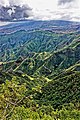


Macizo de Anaga is a mountain range in the northeastern part of the island of Tenerife in the Canary Islands. The highest point is 1,024 m (Cruz de Taborno). It stretches from the Punta de Anaga in the northeast to Cruz del Carmen in the southwest. Anaga features the mountain peaks of Bichuelo, Anambro, Chinobre, Pico Limante, Cruz de Taborno and Cruz del Carmen. The mountains were formed by a volcanic eruption about 7 to 9 million years ago making it the oldest part of the island.[1] Since 1987 it has been protected as a "natural park", reclassified as "rural park" in 1994.[2] Since 2015 it is also an UNESCO Biosphere Reserve and is the place that has the largest number of endemic species in Europe.[3]
It is a remote and wild area characterized by humid forests, such as laurisilva. Native plant species include Ceropegia dichotoma, Ceropegia fusca and Echium virescens. The Macizo de Anaga is also rich in archaeological finds, among which is the Mummy of San Andrés belonging to the ancient Guanche. The main villages in the Macizo de Anaga are San Andrés, Taganana and Igueste de San Andrés. A place in the mountains known as El Bailadero is believed to have been a place where witches were practicing witchcraft and dancing around a bonfire.[citation needed]
See also
- Roques de Anaga
- Punta de Anaga Lighthouse
- Witches of Anaga
References
- ^ Carracedo, Juan Carlos; Troll, Valentin R. (2021-01-01). "North-East Atlantic Islands: The Macaronesian Archipelagos". Encyclopedia of Geology. pp. 674–699. doi:10.1016/B978-0-08-102908-4.00027-8. ISBN 9780081029091. S2CID 226588940.
- ^ Protected natural areas Archived 2013-11-09 at the Wayback Machine
- ^ El macizo de Anaga alberga mayor concentración de endemismos de toda Europa
External links
Wikimedia Commons has media related to Macizo de Anaga.
- Flora of Anaga
- El Bailadero of the witches.
28°31′50″N 16°14′27″W / 28.53056°N 16.24083°W / 28.53056; -16.24083


