Luzit
Place in Jerusalem, Israel
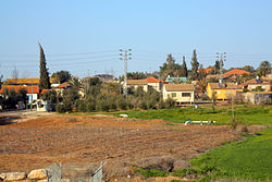
Luzit לוזית | |
|---|---|
 | |
| 31°41′6″N 34°53′11″E / 31.68500°N 34.88639°E / 31.68500; 34.88639 | |
| Country | Israel |
| District | Jerusalem |
| Council | Mateh Yehuda |
| Affiliation | Moshavim Movement |
| Founded | 1955 |
| Founded by | North African Jews |
| Population (2022)[1] | 871 |
Luzit (Hebrew: לוּזִית, lit. 'Almond Tree') is a moshav in central Israel. Located between Beit Shemesh and Kiryat Gat, it falls under the jurisdiction of Mateh Yehuda Regional Council. In 2022 it had a population of 871.[1]
History
The village was established in 1955 by Sephardic Jewish immigrants and refugees from North Africa, led by Shalom de Palenzuela Levi-Kahana and was initially named Dir Duban Bet after the depopulated Arab village of Deir al-Dubban. It was later renamed Luzit after almond trees, which are common in the area.
References
- ^ a b "Regional Statistics". Israel Central Bureau of Statistics. Retrieved 21 March 2024.
- v
- t
- e
- Harel
- Kiryat Anavim
- Ma'ale HaHamisha
- Nahshon
- Netiv HaLamed-Heh
- Ramat Rachel
- Tzora
- Tzova
- Aderet
- Agur
- Aminadav
- Aviezer
- Bar Giora
- Beit Zayit
- Beit Meir
- Beit Nekofa
- Bekoa
- Eshtaol
- Even Sapir
- Gefen
- Giv'at Ye'arim
- Givat Yeshayahu
- Kfar Uria
- Ksalon
- Luzit
- Mevo Beitar
- Mata
- Mahsia
- Mesilat Zion
- Naham
- Nehusha
- Nes Harim
- Neve Ilan
- Neve Michael
- Ora
- Ramat Raziel
- Sdot Micha
- Sho'eva
- Shoresh
- Ta'oz
- Tal Shahar
- Tarum
- Tirosh
- Tzafririm
- Tzelafon
- Yad HaShmona
- Yish'i
- Zanoah
- Zekharia
| Authority control databases: National |
|
|---|


