Listed buildings in Cardiff
Protected buildings in Cardiff, Wales

Map all coordinates using OpenStreetMap
Download coordinates as:
- KML
- GPX (all coordinates)
- GPX (primary coordinates)
- GPX (secondary coordinates)
There are around 1,000 listed buildings in Cardiff,[1] the capital city of Wales. A listed building is one considered to be of special architectural, historical or cultural significance, which is protected from being demolished, extended or altered, unless special permission is granted by the relevant planning authorities. The Welsh Government makes decisions on individual cases, taking advice from the heritage agency Cadw, the Royal Commission on the Ancient and Historical Monuments of Wales and local councils.[2]
Key
| Grade | Criteria[3] |
|---|---|
| Grade I | Buildings of exceptional, usually national, interest (generally the top 2 per cent). |
| Grade II* | Particularly important buildings of more than special interest. |
| Grade II | Buildings of special interest, which warrant every effort being made to preserve them. |
Because of the way in which buildings are listed and the large number of listed buildings within the city, they have been subdivided into Grade I, II* and II buildings, with the Grade II buildings being further split up by area.
Grade I listed buildings
| Name | Photograph | Completed | Date Listed | Function | Location | Grid Ref.[note 1] Geo-coordinates | Description | HB Number[note 2] | Ref. |
|---|---|---|---|---|---|---|---|---|---|
| Animal Wall, and Gates near Clock Tower |  | 1890 | 1952 | Park Wall | Castle Quarter | ST1794576460 51°28′52″N 3°10′59″W / 51.481145676222°N 3.183024021168°W / 51.481145676222; -3.183024021168 | Designed by William Burges and constructed after his death by his assistant, William Frame.[4] The Wall was moved from the front of Cardiff Castle to its current location in 1922. | 21696 | [5] |
| Cardiff Castle | 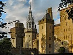 | 1081–927 | 1952 | Castle Wall and Lodge | Castle Quarter | ST1807376595 51°28′57″N 3°10′52″W / 51.482377858563°N 3.1812125493558°W / 51.482377858563; -3.1812125493558 | Built on the foundations of a Roman fort (a small part of the Roman wall of white bricks remains visible at the south-east corner) the above ground construction mostly dates from the Norman period to the late 19th century. A Motte was built by Robert Fitzhamon in 1081 followed by a stone Bailey in the 12th century. Gilbert de Clare built the Black Tower at the south entrance during the 13th century. Much of the remaining castle and walls were constructed or redecorated by the Earls and Marquises of Bute between 1778 and the 1890s in a fantasy gothic style.[6] | 13662 | [7] |
| Cardiff Crown Court | 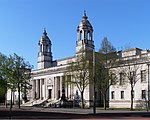 | 1906 | 1966 | Law Courts | Cathays Park | ST1814376839 51°29′04″N 3°10′49″W / 51.484581468039°N 3.1802613632082°W / 51.484581468039; -3.1802613632082 | 13736 | [8] | |
| Castell Coch | 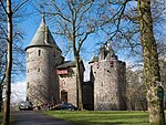 | 1871–?? | 1963 | Castle | Tongwynlais | ST1306182631 51°32′09″N 3°15′18″W / 51.535887521247°N 3.2548616226841°W / 51.535887521247; -3.2548616226841 | Fantasy castle designed by William Burges and built on the ruins of an original 13th-century castle. | 13644 | [9] |
| City Hall |  | 1906 | 1966 | City Hall | Cathays Park | ST1824876911 51°29′07″N 3°10′44″W / 51.485243934532°N 3.1787662423898°W / 51.485243934532; -3.1787662423898 | 13744 | [10] | |
| Former Glamorgan County Hall |  | 1912 | 1966 | County Hall | Cathays Park | ST1805176988 51°29′09″N 3°10′54″W / 51.4859075631°N 3.1816206302281°W / 51.4859075631; -3.1816206302281 | 13738 | [11] | |
| Llandaff Cathedral | 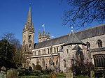 | 1120–1869 | 1952 | Cathedral | Llandaff | ST1555478123 51°29′45″N 3°13′04″W / 51.495742509574°N 3.2178455580854°W / 51.495742509574; -3.2178455580854 | 13710 | [12] | |
| National Museum Cardiff |  | 1913–27 | 1966 | Museum | Cathays Park | ST1833676985 51°29′09″N 3°10′39″W / 51.485921901872°N 3.1775163185366°W / 51.485921901872; -3.1775163185366 | A Beaux-Arts design by the architects Arnold Dunbar Smith and Cecil Brewer. The building as it stands is a truncated version of a scheme they proposed in 1910; the west wing largely following the original design was built in 1962–65 by T. Alwyn Lloyd & Gordon. The remaining space was filled in 1993 by the Alex Gordon Partnership.[13] | 13694 | [14] |
| Park House |  | 1874 | 1966 | House | Castle Quarter | ST1847076874 51°29′06″N 3°10′32″W / 51.484943430601°N 3.1755612292536°W / 51.484943430601; -3.1755612292536 | Designed by William Burges in the French Gothic style, for the Marquis of Bute's chief engineer, James McConnochie.[15] | 13772 | [16] |
| Pierhead Building | 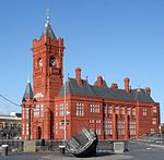 | 1897 | 1975 | Pier Head Building | Butetown | ST1927574484 51°27′49″N 3°09′48″W / 51.463573907169°N 3.1634236506967°W / 51.463573907169; -3.1634236506967 | 14055 | [17] | |
| Bishop's Palace, Llandaff |  | 1266 c. 1266 | 1975 | Bishops Palace Ruins | Llandaff | ST1557477991 51°29′40″N 3°13′03″W / 51.494558898207°N 3.2175259037285°W / 51.494558898207; -3.2175259037285 | An impressive gatehouse and courtyard (now a garden) remains. The Palace was possibly built during the time of Bishop William de Braose. It has similarities to the contemporary Caerphilly Castle.[18] | 13718 | [19] |
| St John the Baptist Church |  | 1460 c. 1460 | 1952 | Church | Castle Quarter | ST1827076411 51°28′51″N 3°10′42″W / 51.480752333465°N 3.1783335916556°W / 51.480752333465; -3.1783335916556 | 13674 | [20] | |
| St Fagans Castle | 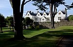 | 1590s c. 1590s | 1977 | Museum | St Fagans | ST1199077145 51°29′11″N 3°16′08″W / 51.486406360736°N 3.2689276967411°W / 51.486406360736; -3.2689276967411 | Multi-gabled Elizabethan house, built before 1596.[21] Its grounds are now used as the St Fagans National History Museum. | 13888 | [22] |
| St German's Church |  | 1884 | 1952 | Church | Adamsdown | ST1958376820 51°29′05″N 3°09′34″W / 51.484617660109°N 3.1595234577824°W / 51.484617660109; -3.1595234577824 | Designed by London architects Bodley & Garner this "tall, spacious and elegant" church also has a contemporary school house.[23] | 13806 | [24] |
| St Margaret's Church |  | 1870 | 1975 | Church | Penylan | ST1993077740 51°29′35″N 3°09′17″W / 51.492937461076°N 3.1547361985818°W / 51.492937461076; -3.1547361985818 | Designed by John Prichard at the behest of the Third Marquess of Bute, this church replaced an ancient chapel on the same site. It includes the Marquess's family mausoleum.[25] | 13819 | [26] |
| St Mellons Church |  | 13th century c. 13th century | 1963 | Church | Old St Mellons | ST2283581404 51°31′35″N 3°06′49″W / 51.526280604923°N 3.1137039141613°W / 51.526280604923; -3.1137039141613 | 13865 | [27] |
Grade II* listed buildings
| Name | Photograph | Completed | Date Listed | Function | Location | Grid Ref.[note 1] Geo-coordinates | Description | HB Number[note 2] | Ref. |
|---|---|---|---|---|---|---|---|---|---|
| Cardiff Bay railway station | 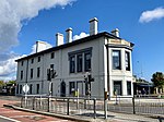 | 1840 | 1975 | Railway Station | Butetown | ST1907074875 51°28′01″N 3°09′59″W / 51.467059522792°N 3.1664635920982°W / 51.467059522792; -3.1664635920982 | 13963 | [28] | |
| Cardiff Central Market | 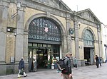 | 1891 | 1975 | Market hall | Castle Quarter | ST1825476350 51°28′49″N 3°10′43″W / 51.480201652586°N 3.1785498054841°W / 51.480201652586; -3.1785498054841 | 13811 | [29] | |
| Coal Exchange |  | 1886 | 1975 | Exchange Building | Butetown | ST1894374698 51°27′56″N 3°10′06″W / 51.465450145714°N 3.168250827942°W / 51.465450145714; -3.168250827942 | 14015 | [30] | |
| Castell-y-mynach |  | Late medieval | 1952 | Manor house | Creigiau | ST0820681065 51°31′16″N 3°19′28″W / 51.521040699923°N 3.3244314654028°W / 51.521040699923; -3.3244314654028 | 13517 | [31] | |
| Castle Arcade (See also Castle Arcade Entrance Block) | 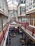 (See also Castle Arcade Entrance Block) | 1887 | 1975 | Shopping Arcade | Castle Quarter | ST1808676400 51°28′50″N 3°10′52″W / 51.480626779385°N 3.1809800886577°W / 51.480626779385; -3.1809800886577 | 13661 | [32] | |
| Cathays Library |  | 1907 | 1975 | Library | Cathays | ST1803678267 51°29′51″N 3°10′56″W / 51.497403018438°N 3.1821340392173°W / 51.497403018438; -3.1821340392173 | A Carnegie library designed by Cardiff architects, Speir & Bevan. The building is in an Arts and Crafts style and has an unusual butterfly plan.[33] | 13681 | [34] |
| Chapel of St. Michael's College | 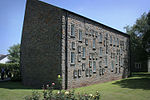 | 1959 | 2004 | Chapel | Llandaff | ST1549777752 51°29′33″N 3°13′07″W / 51.492398899191°N 3.2185774896646°W / 51.492398899191; -3.2185774896646 | 82676 | [35] | |
| St Mary's Church |  | 1963 | Church | St Fagans | ST1211877222 51°29′14″N 3°16′02″W / 51.487118478894°N 3.2671039017113°W / 51.487118478894; -3.2671039017113 | 13871 | [36] | ||
| City United Reformed Church |  | 1866/1893 | 1975 | Chapel | Castle Quarter | ST1865276754 51°29′02″N 3°10′22″W / 51.483890939311°N 3.1729130397707°W / 51.483890939311; -3.1729130397707 | Church rebuilt and enlarged in 1892/3, with an integral tower. Still used as a church. | 13831 | [37] |
| Craig-y-parc House |  | 1914–1918 | 2000 | House | Pentyrch | ST0960280838 51°31′09″N 3°18′15″W / 51.519225763514°N 3.3042581620521°W / 51.519225763514; -3.3042581620521 | 22816 | [38] | |
| Empire House |  | 1991 | Residential | Butetown | ST1898174750 51°27′57″N 3°10′04″W / 51.465923058722°N 3.1677158571021°W / 51.465923058722; -3.1677158571021 | 14007 | [39] | ||
| Entrance Block to Castle Arcade (See also Castle Arcade) |  (See also Castle Arcade) | 1882 | 1999 | Shopping arcade | Castle Quarter | ST1813276398 51°28′50″N 3°10′49″W / 51.48061547304°N 3.1803173632483°W / 51.48061547304; -3.1803173632483 | Built as the Albert Chambers by Peter Price, the entrance block pre-dates the arcade behind by five years.[40] | 21712 | [41] |
| Old Library |  | 1882 | 1978 | Museum, Information Centre and Welsh language Centre | Castle Quarter | ST1834176341 51°28′48″N 3°10′38″W / 51.48013°N 3.17729°W / 51.48013; -3.17729 | Designed by architects James, Seward & Thomas, the building became the Central Library in 1896. Includes stained glass throughout and an entrance hall decorated with tiles. | 14111 | [42] |
| Garden terrace and steps at Craig-y-parc |  Upload Photo | c. 1915 | 2000 | Terrace | Pentyrch | ST0959880815 51°31′08″N 3°18′16″W / 51.519018373062°N 3.3043098881919°W / 51.519018373062; -3.3043098881919 | 22818 | [43] | |
| Gelynis Farmhouse and attached cottage and stable |  | 1977 | Farmhouse and cottage | Radyr | ST1306181630 51°31′37″N 3°15′17″W / 51.526889287446°N 3.2546141676723°W / 51.526889287446; -3.2546141676723 | 13912 | [44] | ||
| House of Fraser, formerly James Howell & Co. |  | 1928–30 | 1988 | Department store | Castle Quarter | ST1827976306 51°28′47″N 3°10′41″W / 51.479809730584°N 3.1781796890139°W / 51.479809730584; -3.1781796890139 | Designed by Sir Percy Thomas.[45] The Beaux-Arts-style building was awarded the RIBA Bronze Medal in 1930.[46] | 14109 | [47] |
| Howell's School Llandaff, Original Building with Big Hall |  | 1858–59 | 1975 | School | Llandaff | ST1592577520 51°29′25″N 3°12′44″W / 51.490377277084°N 3.212358731349°W / 51.490377277084; -3.212358731349 | Designed by Herbert Williams (after Decimus Burton withdrew from the commission).[48] | 13660 | [49] |
| Insole Court |  | 1992 | House | Llandaff | ST1504277720 51°29′31″N 3°13′30″W / 51.492042919315°N 3.2251219858196°W / 51.492042919315; -3.2251219858196 | 14127 | [50] | ||
| Lead Cistern in the east forecourt of St Fagans Castle |  | 1977 | Cistern | St Fagans | ST1201677150 51°29′11″N 3°16′07″W / 51.486455360604°N 3.2685545878629°W / 51.486455360604; -3.2685545878629 | 13885 | [51] | ||
| Llanfair-fach House | Upload Photo | 1995 | House | St Fagans | ST0983579242 51°30′18″N 3°18′02″W / 51.504916451463°N 3.3004922770382°W / 51.504916451463; -3.3004922770382 | 11707 | [52] | ||
| Llanrumney Hall | 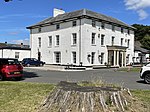 | 1975 | Public House | Llanrumney | ST2171580975 51°31′20″N 3°07′47″W / 51.52226958104°N 3.1297494879218°W / 51.52226958104; -3.1297494879218 | 13646 | [53] | ||
| Loggia at Craig-y-parc and attached terrace walls and steps | Upload Photo | c. 1915 | 2000 | Loggia | Pentyrch | ST0963780820 51°31′09″N 3°18′13″W / 51.519069570889°N 3.303749243971°W / 51.519069570889; -3.303749243971 | 22817 | [54] | |
| Portland House |  | 1927 | 1966 | Bank | Butetown | ST1907274705 51°27′56″N 3°09′59″W / 51.465531570825°N 3.1663958292386°W / 51.465531570825; -3.1663958292386 | 13974 | [55] | |
| New House Hotel |  | c. 1795 | 1977 | House | Rhiwbina | ST1600084133 51°32′59″N 3°12′46″W / 51.549835390308°N 3.212857313818°W / 51.549835390308; -3.212857313818 | 13937 | [56] | |
| Old Leckwith Bridge (partly in the Michaelston community) |  | 16th century | 1952 | Bridge | Canton, Michaelston-y-Fedw | ST1591175248 51°28′12″N 3°12′43″W / 51.469951121446°N 3.2120186613062°W / 51.469951121446; -3.2120186613062 | A three-arched stone bridge with parapet refuges, spanning the River Ely. It dates from before 1536.[57] | 13748 | [58] |
| Pencoed | Upload Photo | 1963 | Farmhouse | Pentyrch | ST0922779861 51°30′37″N 3°18′34″W / 51.510383180675°N 3.3094094136377°W / 51.510383180675; -3.3094094136377 | 13608 | [59] | ||
| South African War Memorial |  | 1909 | 1966 | War Memorial | Cathays Park | ST1822276831 51°29′04″N 3°10′45″W / 51.484521002622°N 3.1791220474241°W / 51.484521002622; -3.1791220474241 | Designed by sculptor Albert Toft and described as "undoubtedly the finest and most original work of sculpture" in Cathays Park.[60] | 13745 | [61] |
| St Andrews United Reformed Church |  | 1900 | 1975 | Chapel | Penylan | ST1926378085 51°29′45″N 3°09′52″W / 51.495943833252°N 3.1644206756459°W / 51.495943833252; -3.1644206756459 | 13753 | [62] | |
| St Augustine's Church |  | 1108 | 1975 | Church | Rumney | ST2143279116 51°30′20″N 3°08′00″W / 51.505518412437°N 3.1334126628628°W / 51.505518412437; -3.1334126628628 | 13672 | [63] | |
| St Denys Church |  | 12th century | 1963 | Church | Lisvane | ST1915083059 51°32′26″N 3°10′02″W / 51.540641711792°N 3.1671908405372°W / 51.540641711792; -3.1671908405372 | 13867 | [64] | |
| St Edeyrn's Church |  | 1963 | Church | Old St Mellons | ST2205781988 51°31′53″N 3°07′30″W / 51.531423516403°N 3.1250456236297°W / 51.531423516403; -3.1250456236297 | 13868 | [65] | ||
| St Isan's Church |  | 11th Century | 1952 | Church | Llanishen | ST1762781836 51°31′46″N 3°11′20″W / 51.529426958493°N 3.188859698806°W / 51.529426958493; -3.188859698806 | 13726 | [66] | |
| St John's College (formerly Ty-to-Maen) |  | 1977 | School | Old St Mellons | ST2304881624 51°31′42″N 3°06′38″W / 51.528287465945°N 3.1106823528726°W / 51.528287465945; -3.1106823528726 | 13941 | [67] | ||
| St Peter's Church |  | 1861 | 1975 | Church | Roath | ST1897077073 51°29′12″N 3°10′06″W / 51.486804362039°N 3.1684077667036°W / 51.486804362039; -3.1684077667036 | 13805 | [68] | |
| Stables to Cardiff Castle in Bute Park |  | 1966 | Stables | Castle Quarter | ST1792676916 51°29′07″N 3°11′00″W / 51.485242152536°N 3.1834036990454°W / 51.485242152536; -3.1834036990454 | 13764 | [69] | ||
| Tabernacle Chapel including attached Hall and forecourt railings |  | 1865 | 1975 | Chapel | Castle Quarter | ST1841676164 51°28′43″N 3°10′34″W / 51.478553024116°N 3.1761744896409°W / 51.478553024116; -3.1761744896409 | Designed by John Hartland and built in 1865 in only six months, described as "one of the finest chapels and most original of the period".[70] | 13722 | [71] |
| The Cathedral School |  | 1744–51 | 1952 | School | Llandaff | ST1567677885 51°29′37″N 3°12′58″W / 51.49362127068°N 3.2160316208874°W / 51.49362127068; -3.2160316208874 | The main building was built as Llandaff Court, the seat of Admiral Thomas Mathews, on the site of the ancient manor house of Bryn-y-Gynnon. Its architect was probably John Wood, who was engaged on the restoration of Llandaff Cathedral at the time of the house's construction.[72] | 13654 | [73] |
| The High Court of Justice, Probate Registry of Wales |  | 1975 | Probate Registry | Llandaff | ST1546377863 51°29′36″N 3°13′09″W / 51.493391632893°N 3.2190937300591°W / 51.493391632893; -3.2190937300591 | 13648 | [74] | ||
| The Old Rectory | 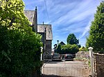 | 1977 | House | St Fagans | ST1214277401 51°29′19″N 3°16′00″W / 51.488731294632°N 3.2668029415731°W / 51.488731294632; -3.2668029415731 | Designed by architects John Prichard and John Pollard Seddon. | 13902 | [75] | |
| University of Wales, Cardiff, including Forecourt Walls | 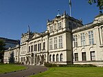 | 1883 | 1966 | University Building | Cathays Park | ST1820877168 51°29′15″N 3°10′46″W / 51.487548457977°N 3.1794018016937°W / 51.487548457977; -3.1794018016937 | 13757 | [76] | |
| Welsh National War Memorial |  | 1928 | 1966 | War Memorial | Cathays Park | ST1813677063 51°29′12″N 3°10′49″W / 51.486594115121°N 3.1804141599961°W / 51.486594115121; -3.1804141599961 | 13742 | [77] | |
| West Lodge to Cardiff Castle, including attached Walls & Gateway |  | 1863 | 1952 | Lodge | Castle Quarter | ST1783776465 51°28′52″N 3°11′04″W / 51.481174915467°N 3.184580075529°W / 51.481174915467; -3.184580075529 | Designed by Alexander Roos to the west of Cardiff Castle as a decorative gatehouse to the estate of the Marquess of Bute. Converted into tea-rooms in 2012, retaining the original Victorian floor tiles.[78] | 21697 | [79] |
Grade II listed buildings
Adamsdown
Butetown and Cardiff Bay
Caerau
| Name | Location Grid Ref.[note 3] Geo-coordinates | Date Listed | Function | Notes | Reference Number | Image |
|---|---|---|---|---|---|---|
| Church of St. Francis of Assisi RC | On the corner of Cowbridge Road West and Caerau Park Road 51°28′27″N 3°15′11″W / 51.4741°N 3.2531°W / 51.4741; -3.2531 (Church of St. Francis of Assisi RC) | 2004 | Roman Catholic church | Built in 1960 to designs by F. R. Bates Son and Price, exterior features a concrete sculpture by Adam Kossowski of St. Francis's vision of Christ on the Cross. | 82629 |  See more images |
| Church of St. Mary | On the north eastern side of Caerau Hillfort 51°28′04″N 3°14′48″W / 51.4678°N 3.2466°W / 51.4678; -3.2466 (Church of St. Mary) | 1980 | Church | Ruined possibly 13th century medieval church restored c.1885 by John Prichard, the diocesan architect of Llandaff. | 13406 | 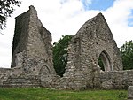 |
| Ely Methodist Church | On the corner of Cowbridge Road West and Colin Road 51°28′57″N 3°14′01″W / 51.4826°N 3.2337°W / 51.4826; -3.2337 (Ely Methodist Church) | 1999 | Methodist church | Built 1911 in a free gothic style with Arts and Crafts influences | 21571 |  |
Canton
This list is incomplete; you can help by adding missing items. (March 2016) |
| Name | Photograph | Date | Location | Description |
|---|---|---|---|---|
| The Corporation, Cowbridge Road East |  | 1889 | 51°28′53″N 3°12′04″W / 51.4814°N 3.2010°W / 51.4814; -3.2010 (The Corporation) | A generous two-storey public house with a four-storey tower, on a prominent corner of Canton. Dating from 1889 and built on Cardiff Corporation land, hence the name.[80] |
| St John the Evangelist Church, St John's Crescent |  | 1854 | 51°28′48″N 3°12′04″W / 51.4799°N 3.2012°W / 51.4799; -3.2012 (St John the Evangelist) | The Church in Wales parish church for Canton, designed by architects John Prichard and John Pollard Seddon in a Gothic Revival style. The aisles were added a few years later and the steeple included 1868–70. Listed in 1975.[81] |
| St Mary of the Angels Church, Kings Road /Hamilton Street |  | 1907 | 51°28′57″N 3°11′42″W / 51.4825°N 3.1950°W / 51.4825; -3.1950 (St Mary of the Angels) | A Roman Catholic church designed by F A Walters, with the tower added in 1916. Listed as "a very good Roman Catholic church designed by a notable Edwardian architect".[82] |
City centre
This list is incomplete; you can help by adding missing items. (March 2013) |
| Name | Photograph | Date | Location | Description |
|---|---|---|---|---|
| Bute Building,[83] King Edward VII Avenue |  | 1916 | 51°29′11″N 3°10′58″W / 51.48652°N 3.18264°W / 51.48652; -3.18264 (Bute Building) | Designed by Percy Thomas and Ivor Davies and opened in 1916 as Cardiff Technical College.[84] |
| Central Station, Central Square |  | 1930 | 51°28′31″N 3°10′40″W / 51.4752°N 3.1779°W / 51.4752; -3.1779 (Central Station) | Considered "the most complete 1930s Great Western Railway station still in existence".[85] |
| Eglwys Dewi Sant, St Andrew's Crescent |  | 1863 | 51°29′06″N 3°10′31″W / 51.4851°N 3.1752°W / 51.4851; -3.1752 (Eglwys Dewi Sant) | Originally designed by architects Prichard & Seddon, but completed to a simpler design. Later additions by William Butterfield.[86] |
| Golden Cross public house, Bute Terrace |  | 1890s c. 1890s | 51°28′36″N 3°10′24″W / 51.4766°N 3.1732°W / 51.4766; -3.1732 (Golden Cross) | Late 19th-century public house, tiled in green and gold. Important interior with decorative tiling and engraved glass.[87] |
| Hayes Island Snack Bar, The Hayes |  | 1911 | 51°28′46″N 3°10′32″W / 51.4794°N 3.1756°W / 51.4794; -3.1756 (Hayes Island Snack Bar) | Originally opened as a parcels office.[88] |
| New Theatre, Greyfriars Road |  | 1906 | 51°29′01″N 3°10′32″W / 51.48366°N 3.17553°W / 51.48366; -3.17553 (New Theatre) | Designed by architects Runtz and Ford, with a facade of Bath stone and brick.[89] |
| Old Custom House, Bute Terrace |  | 1845 c. 1845 | 51°28′35″N 3°10′33″W / 51.4764°N 3.1757°W / 51.4764; -3.1757 (Old Custom House) | Two-storey five-bay building, originally sited next to the Glamorganshire Canal. Listed for its importance to Cardiff's commercial history.[90] Demolished by developers in early 2019, with only the facade wall retained. |
| Parc Hotel, Queen Street |  | 1884 c. 1884 | 51°28′57″N 3°10′22″W / 51.4824°N 3.1729°W / 51.4824; -3.1729 (Parc Hotel) | |
| Prince of Wales Theatre, Wood Street and St Mary Street |  | 1878 | 51°28′39″N 3°10′40″W / 51.47750°N 3.17790°W / 51.47750; -3.17790 (Prince of Wales Theatre) | Built to a Venetian Gothic design by W. D. Bleasley and T. Waring. Later remodelled in a Greek Revival style by Willmott & Smith.[91] Now a pub. |
| Royal Hotel, St Mary Street | 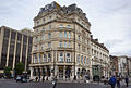 | 1866 | 51°28′40″N 3°10′39″W / 51.4777°N 3.1774°W / 51.4777; -3.1774 (Royal Hotel) | |
| Water Tower at Cardiff Central railway station |  | 1932 | 51°28′32″N 3°10′49″W / 51.4755°N 3.1804°W / 51.4755; -3.1804 (Water Tower) | Great Western Railway water tower, 15 metres in height, built in concrete with a fluted base.[85] In 1984 it was embellished with a painted design of giant daffodils.[92] It was repainted in cream and beige, the colours of the GWR, in 2012.[85] |
Cathays
Cyncoed
Ely
| Name | Location Grid Ref.[note 4] Geo-coordinates | Date Listed | Function | Notes | Reference Number | Image |
|---|---|---|---|---|---|---|
| Church of the Resurrection, Ely | Grand Avenue, Ely 51°28′44″N 3°14′57″W / 51.4789°N 3.2492°W / 51.4789; -3.2492 (Church of the Resurrection, Ely) | 2001 | Church in Wales church building | Completed in the 1930s, designed in the Byzantine style in rich brown brick. The church was designed by T. Roderick of Aberdare and provided at a cost of £10,000 by Lord Glanely in memory of his wife, Ada. Design inspired by the Community of the Resurrection in Mirfield, West Yorkshire, by Walter Tapper.[93] | 25795 |  |
| Milepost outside No 322 | On Cowbridge Road West, south west of the junction with Crossways Road 51°28′35″N 3°14′50″W / 51.4764°N 3.2473°W / 51.4764; -3.2473 (Milepost outside No 322) | 1976 | Mile post | A cast-iron Gothic style mile post dating from 1835. One of a number of mileposts to the west of Cardiff on the A48. Inscribed 'LANDAFF PARISH' on a rectangular panel, with 'CARDIFF DISTRICT' inscribed on the top. Left hand panel inscribed 'TO CARDIFF 3', right hand side inscribed 'TO COWBRIDGE 9'. 'LONDON 161' inscribed at base. | 14084 |  |
| Milepost outside the Western Cemetery | On Cowbridge Road West, opposite Knightswell Road, near the main entrance of the Western Cemetery 51°28′06″N 3°15′57″W / 51.4684°N 3.2657°W / 51.4684; -3.2657 (Milepost outside the Western Cemetery) | 1976 | Mile post | A cast-iron Gothic style mile post dating from 1835. One of a number of mileposts to the west of Cardiff on the A48. Inscribed 'MICHAELSTONE PARISH' on a rectangular panel, with 'CARDIFF DISTRICT' inscribed on the top. Left hand panel inscribed 'TO CARDIFF 4', right hand side inscribed 'TO COWBRIDGE 8'. 'LONDON 162' inscribed at base. | 14083 | 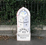 |
Fairwater
Flat Holm (Island)
This list is incomplete; you can help by adding missing items. (April 2013) |
| Name | Photograph | Date | Location | Description |
|---|---|---|---|---|
| Foghorn Station, Flat Holm |  | 1906 | 51°22′39″N 3°07′03″W / 51.3776°N 3.1174°W / 51.3776; -3.1174 (Foghorn Station) | Built by the Trinity House lighthouse authority and in use as a fog warning until 1988.[94] |
| Isolation Hospital (ruins),[95] Flat Holm |  | 1896 | 51°22′38″N 3°07′16″W / 51.3772°N 3.1210°W / 51.3772; -3.1210 (Isolation Hospital) | A unique offshore Isolation Hospital for cholera patients, built in single storey red brick[96] and closed in 1935. |
Gabalfa
| Name | Photograph | Date | Location | Description |
|---|---|---|---|---|
| Allensbank Primary School,[97] Llanishen Street |  | 1904 | 51°30′06″N 3°11′07″W / 51.5016°N 3.1854°W / 51.5016; -3.1854 (Allensbank Primary School) | Designed by Veall and Sant and opened in 1904 |
| Park Lodge,[98] Bute Park |  | 1872–73 | 51°28′52″N 3°11′05″W / 51.4811°N 3.1846°W / 51.4811; -3.1846 (Park Lodge) | Built 1872–73 for the 3rd Marquess of Bute as the north lodge of Cardiff Castle park and probably designed by Charles Rigg |
Grangetown
Heath
| Name | Photograph | Date | Location | Description |
|---|---|---|---|---|
| The Cross Inn (now known as The Aneurin Bevan),[99] Caerphilly Road |  | 1994 | 51°30′28″N 3°12′00″W / 51.5077°N 3.1999°W / 51.5077; -3.1999 (The Aneurin Bevan) | Listed as "a well-detailed public house in the Queen Ann revival style". |
Lisvane
| Name | Photograph | Date | Location | Description |
|---|---|---|---|---|
| Carn Ingli,[100] Lisvane Road (Carn Ingli is house on the left in image) |  | 1931 | 51°32′22″N 3°10′01″W / 51.5395°N 3.1669°W / 51.5395; -3.1669 (Carn Ingli, Lisvane) | Datestone 1931 and inscription JET, denotes builder as J E Turner trading as E Turner and Sons. |
| Cerrig Llwyd,[101] Lisvane Road (Cerrig Llwyd is house on the right in image) | ||||
| Lisvane Baptist Chapel,[102] Rudry Road |  | 1858 | 51°33′01″N 3°09′41″W / 51.5503°N 3.1615°W / 51.5503; -3.1615 (The former Lisvane Baptist Chapel, Lisvane) | Of important architectural interest as a plain country chapel from the mid 19th century on an earlier site. |
| Outdoor Baptistry by Lisvane Baptist Chapel,[103] Rudry Road | 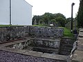 | c.1841 | 51°33′01″N 3°09′41″W / 51.5503°N 3.1615°W / 51.5503; -3.1615 (The former Lisvane Baptist Chapel, Lisvane) | Included as an unusual surviving outdoor baptistery. |
Llandaff
| Name | Photograph | Date | Location | Description |
|---|---|---|---|---|
| St Andrew[104] | 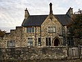 | Built 1859-61 | 51°29′40″N 3°13′06″W / 51.49443°N 3.2182°W / 51.49443; -3.2182 (St Andrew, Llandaff) | Included as an unaltered design by Ewan Christian and for its group value with the other listed buildings around The Cathedral Green and on the High Street. |
| St Cross[105] |  | Built 1859-61 | 51°29′39″N 3°13′06″W / 51.49426°N 3.21833°W / 51.49426; -3.21833 (St Cross, Llandaff) | |
| 6 High Street[106] |  | Probably 18th century | 51°29′41″N 3°13′06″W / 51.4946°N 3.2184°W / 51.4946; -3.2184 (6 High Street, Llandaff) | Included as a largely 18th-century house and for its group value with the other listed buildings around The Cathedral Green and on the High Street. Now in commercial use as a teahouse |
| 19 High Street[107] |  | Probably mid-19th century | 51°29′38″N 3°13′08″W / 51.49383°N 3.2189°W / 51.49383; -3.2189 (19 High Street, Llandaff) | Included as a largely 18th-century house and for its group value with the other listed buildings around The Cathedral Green and on the High Street. |
Llandaff North
| Name | Location Grid Ref.[note 5] Geo-coordinates | Date Listed | Function | Notes | Reference Number | Image |
|---|---|---|---|---|---|---|
| Afon Taff Viaduct | Over the River Taff on the Cardiff-Merthyr line between Llandaff and Raydr stations 51°30′40″N 3°14′23″W / 51.5111°N 3.2397°W / 51.5111; -3.2397 (Afon Taff Viaduct) | 2004 | Railway bridge | Built for the Taff Vale Railway in three stages and was designed by Isambard Kingdom Brunel from 1845 to 1850, subsequently widened. | 82590 |  See more images |
Llanishen
Morganstown
Pentyrch
Penylan
Pontprennau
| Name | Location Grid Ref.[note 6] Geo-coordinates | Date Listed | Function | Notes | Reference Number | Image |
|---|---|---|---|---|---|---|
| Glan-y-nant | Graig Llwyn Road 51°32′50″N 3°09′17″W / 51.5472°N 3.1546°W / 51.5472; -3.1546 (Glan-y-nant) | 1977 | House | A small two storey thatched house probably dating from the 18th century with a 20th-century extension at the rear. | 13861 |  |
| Pant-teg (aka Panteg) | off St. Mellons Road 51°32′13″N 3°09′25″W / 51.537°N 3.1569°W / 51.537; -3.1569 (Pant-teg (aka Panteg)) | 1977 | Farmhouse | A traditional long farmhouse dating from the mid 17th century but remodelled and extended in the 18th or early 19th century. | 13935 | Upload Photo |
Radyr
| Name | Photograph | Date | Location | Description |
|---|---|---|---|---|
| Church of St. John the Baptist[108] |  | Probably 14th century | 51°30′14″N 3°14′29″W / 51.5038°N 3.2415°W / 51.5038; -3.2415 (St. John's Church) | Medieval church, restored and altered c. 1885 |
Rhiwbina
| Name | Location Grid Ref.[note 7] Geo-coordinates | Date Listed | Function | Notes | Reference Number | Image |
|---|---|---|---|---|---|---|
| Briwnant Farmhouse and adjoining farm range | 51°32′39″N 3°13′12″W / 51.5442°N 3.2199°W / 51.5442; -3.2199 (Briwnant Farmhouse and adjoining farm range) | 1975 | Farmhouse | Small stone farmhouse, possibly 18th century, occasionally known as Briwnant Fawr. | 13821 | Upload Photo |
| Hafod Lwyd | 11 Heol Wen, Rhiwbina Garden Village 51°31′21″N 3°13′07″W / 51.5224°N 3.21865°W / 51.5224; -3.21865 (Hafod Lwyd) | 2001 | House | Detached house, built by the architect Thomas Alwyn Lloyd for his own occupation c.1920. Faces Lon Isa from the west end of the garden village | 25893 |  |
| The Long Barn and attached courtyard wall, gates and railings | On farm track off Thornhill Road 51°32′59″N 3°12′37″W / 51.5496°N 3.2104°W / 51.5496; -3.2104 (The Long Barn and attached courtyard wall, gates and railings) | 2001 | Barn | Former 18th century long stable, barn, and coach house, now converted into housing | 15758 |  |
| Llanishen Fach | Heol Erwin, Rhiwbina 51°31′55″N 3°12′31″W / 51.5319°N 3.2086°W / 51.5319; -3.2086 (Llanishen Fach) | 1975 | Farmhouse | Former farmhouse, white painted stone with slate roof. Built on site of older house associated with the Williams and Wyndham Lewis families. | 13724 |  |
| Pantysgawen | On farm track off Thornhill Road 51°32′36″N 3°12′37″W / 51.5432°N 3.2102°W / 51.5432; -3.2102 (Pantysgawen) | 1975 | Farmhouse | Small single storey 17th or 18th century farmhouse. | 13810 | Upload Photo |
| Post Box opposite 27 Lon Isa | Lon Isa, Rhiwbina Garden Village 51°31′23″N 3°12′57″W / 51.523°N 3.2157°W / 51.523; -3.2157 (Post Box opposite 27 Lon Isa) | 2001 | Postbox | Pillar box erected at the same period as the houses of the garden village; inscribed with the monogram of King George V and its manufacturer, the Carron Company of Stirlingshire. | 25924 |  |
| Telephone box in Pen-y-dre adjacent to branch library | Opposite Rhiwbina Library on Pen-y-dre 51°31′17″N 3°12′46″W / 51.5215°N 3.2129°W / 51.5215; -3.2129 (Telephone box in Pen-y-dre adjacent to branch library) | 1989 | Red telephone box | A K6 red telephone box designed by Giles Gilbert Scott. The design dates from 1936. | 14120 |  |
| The Wendy House | Off Heol-y-deri to Y Groes, close to 16 Y Groes 51°31′20″N 3°12′47″W / 51.5223°N 3.213°W / 51.5223; -3.213 (The Wendy House) | 2001 | Office | Small single storey building, originally used as offices. Plaques record the Rhiwbina Garden Village Conservation Area and the Rhiwbina Garden Village Residents Association. | 25892 |  See more images |
Riverside
Roath
Rumney
St Fagans
St Mellons
Splott
| Name | Photograph | Date | Location | Description |
|---|---|---|---|---|
| St. Alban-on-the-Moors Church[109] |  | 1911 | 51°29′11″N 3°08′58″W / 51.4863°N 3.1495°W / 51.4863; -3.1495 | Roman Catholic place of worship. |
Tongwynlais
Trowbridge
Whitchurch
| Name | Photograph | Date | Location | Description |
|---|---|---|---|---|
| Bridge House, 88 Merthyr Road[110] |  | c.1800 | ||
| Former Towpath Bridge to Glamorganshire Canal[111] | Late 18th to mid 19th century | 51°30′43″N 3°14′16″W / 51.5119°N 3.2379°W / 51.5119; -3.2379 (Former Towpath Bridge) | ||
| Front wall, gate piers and gate of Bridge House, 88 Merthyr Road[112] |  | c.1800 | ||
| Garden Wall, Privy and Gatepiers of Oak Cottage[113] | Early 19th century | |||
| St Mary's Church[114] |  | 1884 | 51°30′48″N 3°13′16″W / 51.5133°N 3.2211°W / 51.5133; -3.2211 (St Mary's Church) | Anglican place of worship |
| The Laurels, 27 Penlline Road[115] |  | Mid 19th century | Villa in Tudor style | |
| Oak Cottage[116] | 17th to 19th century | |||
| The Pines, Old Church Road[117] |  | Early to mid 19th century | ||
| Six Gables, 27A Penlline Road[118] | 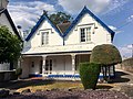 | Mid 19th century | ||
| Tabernacle Chapel, Merthyr Road[119] |  | 1866 | ||
| Ty-Mawr, Ty Mawr Road[120] | 1583 | 51°30′40″N 3°14′09″W / 51.5111°N 3.2359°W / 51.5111; -3.2359 (Ty-Mawr) | One of the oldest houses in Glamorgan, substantially altered in the nineteenth century.[121] | |
| Whitchurch Hospital, Park Road[122] |  | 1908 | 51°31′01″N 3°13′55″W / 51.51687°N 3.23184°W / 51.51687; -3.23184 (Whitchurch Hospital) | A former mental hospital. The hospital chapel and six octagonal shelters in the grounds are separately listed as Grade II.[123][124][122][125][126][127][128][129] |
| Whitchurch Library, Park Road[130] | 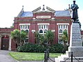 | 1904 | 51°30′58″N 3°13′31″W / 51.5160°N 3.2254°W / 51.5160; -3.2254 (Whitchurch Library) | A Carnegie Library designed by R and S Williams of Cardiff. |
| Whitchurch War Memorial, Park Road[131] |  | c. 1920 | 51°30′58″N 3°13′30″W / 51.5160°N 3.22513°W / 51.5160; -3.22513 (Whitchurch Library) | Erected as a memorial to the dead of the Great War. Later inscription to commemorate the dead of World War II. |
See also
Notes
- ^ a b Sometimes known as OSGB36, the grid reference is based on the British national grid reference system used by the Ordnance Survey.
- ^ a b The "HB Number" is a unique number assigned to each listed building by Cadw.
- ^ Sometimes known as OSGB36, the grid reference is based on the British national grid reference system used by the Ordnance Survey.
- ^ Sometimes known as OSGB36, the grid reference is based on the British national grid reference system used by the Ordnance Survey.
- ^ Sometimes known as OSGB36, the grid reference is based on the British national grid reference system used by the Ordnance Survey.
- ^ Sometimes known as OSGB36, the grid reference is based on the British national grid reference system used by the Ordnance Survey.
- ^ Sometimes known as OSGB36, the grid reference is based on the British national grid reference system used by the Ordnance Survey.
Sources
- Cardiff, Wales, BritishListedBuildings.co.uk
- Hilling, John B. (1973). Cardiff and the Valleys: Architecture and Townscape. London: Lund Humphries.
- Newman, John (1995). Glamorgan: Mid Glamorgan, South Glamorgan and West Glamorgan. The Buildings of Wales. London: Penguin. ISBN 0-14-071056-6.
References
- ^ "Conservation of the built environment". Cardiff Council. Retrieved 20 March 2016.
- ^ Listed Buildings in Wales: What is Listing? (PDF) (third ed.), Cadw, 2005, p. 4, retrieved 19 March 2013
- ^ Listed Buildings in Wales: What is Listing? (PDF) (third ed.), Cadw, 2005, p. 6, retrieved 19 March 2013
- ^ "Castle Timeline". Castle History. Cardiff Castle website. 12 March 2013. Retrieved 17 March 2013.
- ^ "Animal Wall, and Gates near Clock Tower". British Listed Buildings. Retrieved 20 July 2013.
- ^ "Cardiff Castle and Bute Park". Coflein. Royal Commission on the Ancient and Historical Monuments of Wales. Archived from the original on 21 February 2014. Retrieved 17 March 2013.
- ^ "Cardiff Castle". British Listed Buildings. Retrieved 20 July 2013.
- ^ "Law Courts". British Listed Buildings. Retrieved 20 July 2013.
- ^ "Castell Coch". British Listed Buildings. Retrieved 20 July 2013.
- ^ "Cardiff City Hall". British Listed Buildings. Archived from the original on 16 June 2016. Retrieved 20 July 2013.
- ^ "Former Glamorgan County Hall". British Listed Buildings. Retrieved 20 July 2013.
- ^ "Cathedral Church of St. Peter and St. Paul". British Listed Buildings. Retrieved 20 July 2013.
- ^ Newman 1995, pp. 226–27
- ^ "National Museum of Wales". British Listed Buildings. Retrieved 20 July 2013.
- ^ The Buildings of Wales: Glamorgan, page 102.
- ^ "Park House". British Listed Buildings. Retrieved 20 July 2013.
- ^ "Pier Head Building". British Listed Buildings. Retrieved 20 July 2013.
- ^ Pettifer, Adrian (2000). Welsh Castles: A Guide by Counties. The Boydell Press. p. 97. ISBN 0-85115-778-5.
- ^ "Ruins of the Old Bishop's Palace". British Listed Buildings. Retrieved 20 July 2013.
- ^ "Church of St John The Baptist". British Listed Buildings. Retrieved 20 July 2013.
- ^ Glamorgan: Later Castles. R.C.A.H.M.W. 2000. p. 341. ISBN 1-871184-22-3.
- ^ "St Fagans Castle". British Listed Buildings. Retrieved 20 July 2013.
- ^ The Buildings of Wales: Glamorgan, page 95.
- ^ "Church of St German of Auxerre". British Listed Buildings. Retrieved 20 July 2013.
- ^ "St Margaret's Church, Roath Parish". Roath.org.uk. Retrieved 30 March 2013.
- ^ "Church of St Margaret". British Listed Buildings. Retrieved 20 July 2013.
- ^ "Church of St Mellon". British Listed Buildings. Retrieved 20 July 2013.
- ^ "Cardiff Bay Station". British Listed Buildings. Retrieved 20 July 2013.
- ^ "Cardiff Central Market". British Listed Buildings. Retrieved 20 July 2013.
- ^ "Cardiff Exchange Building". British Listed Buildings. Retrieved 20 July 2013.
- ^ "Castell-y-mynach". British Listed Buildings. Retrieved 20 July 2013.
- ^ "Castle Arcade". British Listed Buildings. Retrieved 20 July 2013.
- ^ "Cathays Library, Cathays". British Listed Buildings (text from Cadw listing). Retrieved 21 March 2013.
- ^ "Cathays Library". British Listed Buildings. Retrieved 20 July 2013.
- ^ "Chapel of St. Michael's College". British Listed Buildings. Retrieved 20 July 2013.
- ^ "Church of St Mary the Blessed Virgin". British Listed Buildings. Retrieved 20 July 2013.
- ^ "City United Reformed Church". British Listed Buildings. Retrieved 20 July 2013.
- ^ "Craig-y-parc House". British Listed Buildings. Retrieved 20 July 2013.
- ^ "Empire House". British Listed Buildings. Retrieved 20 July 2013.
- ^ Hilling 1973, p. 84
- ^ "Entrance Block to Castle Arcade". British Listed Buildings. Retrieved 20 July 2013.
- ^ "Former Central Library". British Listed Buildings. Retrieved 20 July 2013.
- ^ "Garden terrace and steps at Craig-y-parc". British Listed Buildings. Retrieved 20 July 2013.
- ^ "Gelynis Farmhouse and attached cottage and stable". British Listed Buildings. Retrieved 20 July 2013.
- ^ Newman 1995, p. 214
- ^ Thomas, Norman Percy. "Thomas, Sir Percy Edward". Dictionary of Welsh Biography. National Library of Wales. Retrieved 28 September 2013.
- ^ "Howells Department Store". British Listed Buildings. Retrieved 20 July 2013.
- ^ Newman 1995, p. 260
- ^ "Howells School, Original Building with Big Hall". British Listed Buildings. Retrieved 20 July 2013.
- ^ "Insole Court". British Listed Buildings. Retrieved 20 July 2013.
- ^ "Lead Cistern in the east forecourt of St Fagans Castle". British Listed Buildings. Retrieved 20 July 2013.
- ^ "Llanfair-fach House". British Listed Buildings. Retrieved 20 July 2013.
- ^ "Llanrumney Hall PH". British Listed Buildings. Retrieved 20 July 2013.
- ^ "Loggia at Craig-y-parc and attached terrace walls and steps". British Listed Buildings. Retrieved 20 July 2013.
- ^ "National Westminster Bank". British Listed Buildings. Retrieved 20 July 2013.
- ^ "New House Hotel". British Listed Buildings. Retrieved 20 July 2013.
- ^ "Leckwith Old Bridge, Leckwith, Cardiff (24126)". Coflein. RCAHMW. Retrieved 31 March 2013.
- ^ "Old Leckwith Bridge (partly in the Michaelston community)". British Listed Buildings. Retrieved 20 July 2013.
- ^ "Pencoed". British Listed Buildings. Retrieved 20 July 2013.
- ^ The Buildings of Wales: Glamorgan, page 107.
- ^ "South African War Memorial". British Listed Buildings. Retrieved 20 July 2013.
- ^ "St Andrews United Reformed Church". British Listed Buildings. Retrieved 20 July 2013.
- ^ "Church of St Augustine". British Listed Buildings. Retrieved 20 July 2013.
- ^ "Church of St Denys". British Listed Buildings. Retrieved 20 July 2013.
- ^ "Church of St Edyern". British Listed Buildings. Retrieved 20 July 2013.
- ^ "Church of St. Isan". British Listed Buildings. Retrieved 20 July 2013.
- ^ "St John's College (formerly Ty-to-Maen)". British Listed Buildings. Retrieved 20 July 2013.
- ^ "Church of St Peter". British Listed Buildings. Retrieved 20 July 2013.
- ^ "Stables to Cardiff Castle in Bute Park". British Listed Buildings. Retrieved 20 July 2013.
- ^ Jones, Anthony L. (1996). Welsh Chapels (2nd ed.). National Museum of Wales. p. 62. ISBN 0-7509-1162-X.
- ^ "Tabernacle Chapel including attached Hall and forecourt railings". British Listed Buildings. Retrieved 20 July 2013.
- ^ Hilling 1973, p. 27
- ^ "The Cathedral School". British Listed Buildings. Retrieved 20 July 2013.
- ^ "The High Court of Justice, Probate Registry of Wales". British Listed Buildings. Retrieved 20 July 2013.
- ^ "The Old Rectory". British Listed Buildings. Retrieved 20 July 2013.
- ^ "University of Wales, Cardiff, including Forecourt Walls". British Listed Buildings. Retrieved 20 July 2013.
- ^ "Welsh National War Memorial". British Listed Buildings. Retrieved 20 July 2013.
- ^ Henry, Graham (24 March 2012). "Bute Park's historic West Lodge reopens as Pettigrew Tea Rooms". WalesOnline.co.uk. Retrieved 20 March 2013.
- ^ "West Lodge to Cardiff Castle, including attached Walls & Gateway". British Listed Buildings. Retrieved 20 July 2013.
- ^ "The Corporation P.H., Riverside". British Listed Buildings. Retrieved 23 March 2016.
- ^ "Church of St John the Evangelist, Canton". British Listed Buildings. Retrieved 23 March 2016.
- ^ "Church of St Mary of the Angels R.C., Riverside". British Listed Buildings. Retrieved 23 March 2016.
- ^ "Bute Building". British Listed Buildings. Retrieved 11 August 2017.
- ^ "Technical College; Bute Building; University of Wales Institute of Science and Technology (31905)". Coflein. RCAHMW. Retrieved 21 March 2013.
- ^ a b c Henry, Graham (19 June 2012). "Cardiff Central's landmark water tower renovation starts – without a daffodil in sight". Wales Online. Retrieved 2 April 2013.
- ^ "Eglwys Dewi Sant, Cardiff; St Andrew's Church, Cardiff (14283)". Coflein. RCAHMW. Retrieved 2 February 2018.
- ^ "Golden Cross Public House". British Listed Buildings. Retrieved 1 April 2013.
- ^ Williams, Stewart (1973). The Cardiff Book. p. 66. ISBN 0900807059.
- ^ "History of the New Theatre". New Theatre website. Retrieved 21 March 2013.
- ^ "Old Custom Housee". British Listed Buildings. Retrieved 17 February 2019.
- ^ Newman 1995, p. 214.
- ^ McWatt, Julia (26 November 2011). "Cardiff Central station water tower decoration plans slammed by painter". South Wales Echo. Retrieved 7 April 2013.
- ^ Old, Harry. "Church of the Resurrection". History. CaerauwithEly.org. Retrieved 21 March 2013.
- ^ "Tourism hope for island's foghorn". BBC Wales News. 30 April 2000. Retrieved 2 April 2013.
- ^ "Former Isolation Hospital (Main Block) Flat Holm Island". British Listed Buildings. Retrieved 2 April 2013.
- ^ "Flat Holm Isolation Hospital, Flat Holm Island (31783)". Coflein. RCAHMW. Retrieved 2 April 2013.
- ^ "Allensbank Primary School, Infants, Gabalfa". British Listed Buildings. Retrieved 10 December 2016.
- ^ "Park Lodge, Gabalfa". British Listed Buildings. Retrieved 10 December 2016.
- ^ "Cross Inn". British Listed Buildings. Retrieved 23 January 2018.
- ^ "Carn Ingli". British Listed Buildings. Retrieved 10 December 2016.
- ^ "Cerrig Llwyd". British Listed Buildings. Retrieved 10 December 2016.
- ^ "Lisvane Baptist Chapel". British Listed Buildings. Retrieved 10 December 2016.
- ^ "Outdoor Baptistry by Lisvane Baptist Chapel". British Listed Buildings. Retrieved 10 December 2016.
- ^ "St. Andrew". British Listed Buildings. Retrieved 13 October 2022.
- ^ "St. Cross". British Listed Buildings. Retrieved 16 October 2022.
- ^ "No.6 High Street, Llandaff, South Glamorgan". British Listed Buildings. Retrieved 3 March 2018.
- ^ Cadw. "19 High Street, Llandaff (Grade II) (13732)". National Historic Assets of Wales. Retrieved 6 November 2022.
- ^ "Church of St. John the Baptist, Llandaff". British Listed Buildings. Retrieved 14 November 2014.
- ^ "Church of St Alban's On the Moors, Cardiff, Cardiff". britishlistedbuildings.co.uk. Retrieved 27 December 2020.
- ^ Cadw. "Bridge House (13754)". National Historic Assets of Wales.
- ^ Cadw. "Former Towpath Bridge to Glamorganshire Canal (26716)". National Historic Assets of Wales.
- ^ Cadw. "Front Wall, Gatepiers and Gate of No 88 (Bridge House) (26713)". National Historic Assets of Wales.
- ^ Cadw. "Privy and Gatepiers of Oak Cottage (26712)". National Historic Assets of Wales.
- ^ Cadw. "Church of St. Mary (13673)". National Historic Assets of Wales.
- ^ Cadw. "The Laurels (13776)". National Historic Assets of Wales.
- ^ Cadw. "Oak Cottage (13815)". National Historic Assets of Wales.
- ^ Cadw. "The Pines (13816)". National Historic Assets of Wales.
- ^ Cadw. "Six Gables (26711)". National Historic Assets of Wales.
- ^ Cadw. "Tabernacle Chapel (21572)". National Historic Assets of Wales.
- ^ Cadw. "Ty Mawr (13814)". National Historic Assets of Wales.
- ^ Newman 1995, p. 314
- ^ a b Cadw. "Whitchurch Hospital (11715)". National Historic Assets of Wales.
- ^ Cadw. "Octagonal Shelter in Grounds to west of Whitchurch Hospital (11708)". National Historic Assets of Wales.
- ^ Cadw. "Octagonal Shelter in Grounds to south-west of Whitchurch Hospital (11709)". National Historic Assets of Wales.
- ^ Cadw. "Octagonal Shelter in Grounds to south-south-west of Whitchurch Hospital (11710)". National Historic Assets of Wales.
- ^ Cadw. "Octagonal Shelter in Grounds to south-south-east of Whitchurch Hospital (11711)". National Historic Assets of Wales.
- ^ Cadw. "Octagonal Shelter in Grounds to south-east of Whitchurch Hospital (11712)". National Historic Assets of Wales.
- ^ Cadw. "Octagonal Shelter in Grounds to east of Whitchurch Hospital (11713)". National Historic Assets of Wales.
- ^ Cadw. "Chapel at Whitchurch Hospital (11714)". National Historic Assets of Wales.
- ^ Cadw. "Whitchurch Free Library (26715)". National Historic Assets of Wales.
- ^ Cadw. "Whitchurch War Memorial (26714)". National Historic Assets of Wales.
External links
Wikimedia Commons has media related to Listed buildings in Cardiff.
- Listed and Locally Listed Buildings, Cardiff Council.
- Interactive map showing the locations of listed buildings – Cardiff Council
- v
- t
- e

- Culture
- Economy
- Education
- Landmarks and visitor attractions
- Media
- Politics
- Sport
- Transport
- Adamsdown
- Birchgrove
- Butetown
- Caerau
- Canton
- Cardiff Bay
- Cardiff Gate
- Cathays
- Creigiau
- Cyncoed
- Danescourt
- Ely
- Fairwater
- Gabalfa
- Grangetown
- Heath
- Lisvane
- Llandaff
- Llandaff North
- Llanishen
- Llanrumney
- Pentrebane
- Pentwyn
- Pentyrch
- Penylan
- Plasdwr
- Pontcanna
- Pontprennau
- Radyr and Morganstown
- Rhiwbina
- Riverside
- Roath
- Rumney
- Splott
- St Fagans
- St Mellons
- Thornhill
- Tongwynlais
- Tremorfa
- Trowbridge
- Whitchurch
 Geography
 Wales
Wales


| |
|---|---|
|

| |
|---|---|
|
| |
|---|---|
| Styles | |
| Buildings and structures | |
| Other | |
| |


