List of historic places in Cumberland County, Nova Scotia
This is a list of historic places in Cumberland County, Nova Scotia.
Map all coordinates using OpenStreetMap
Download coordinates as:
- KML
- GPX (all coordinates)
- GPX (primary coordinates)
- GPX (secondary coordinates)
List of historic places
| Name | Address | Coordinates | Government recognition (CRHP №) | Image | |
|---|---|---|---|---|---|
| Acadia Lodge No. 13 A.F. & A.M. | 14 Victoria Street Pugwash NS | 45°51′01″N 63°39′43″W / 45.8503°N 63.662°W / 45.8503; -63.662 (Acadia Lodge No. 13 A.F. & A.M.) | Nova Scotia (10939), Pugwash municipality (12775) |  Upload Photo | |
| Advocate United Church | 3680 Highway 209 Advocate Harbour NS | 45°20′07″N 64°46′51″W / 45.3352°N 64.7807°W / 45.3352; -64.7807 (Advocate United Church) | Advocate Harbour municipality (11874) | Upload Photo | |
| Amherst Dominion Public Building | 98 East Victoria Street Amherst NS | 45°50′03″N 64°12′46″W / 45.8342°N 64.2128°W / 45.8342; -64.2128 (Amherst Dominion Public Building) | Nova Scotia (14641) | Upload Photo | |
| Amherst Point Baptist Church | 908 Southampton Road Amherst Point NS | 45°47′54″N 64°15′34″W / 45.7982°N 64.2595°W / 45.7982; -64.2595 (Amherst Point Baptist Church) | Amherst Point municipality (10996) | Upload Photo | |
| Armoury | Amherst NS | 45°50′03″N 64°12′30″W / 45.8341°N 64.2082°W / 45.8341; -64.2082 (Armoury) | Federal (9708) | Upload Photo | |
| The Bank of Montreal Building | 100 Victoria Street Amherst NS | 45°50′04″N 64°12′46″W / 45.8344°N 64.2127°W / 45.8344; -64.2127 (The Bank of Montreal Building) | Nova Scotia (6497) | Upload Photo | |
| Beaubassin National Historic Site of Canada | Highway 4 Fort Lawrence NS | 45°50′53″N 64°16′00″W / 45.8481°N 64.2666°W / 45.8481; -64.2666 (Beaubassin National Historic Site of Canada) | Federal (13964) |  More images | |
| Building 16 | Nappan Experimental Farm, Highway 302 Nappan NS | 45°45′32″N 64°14′21″W / 45.759°N 64.2391°W / 45.759; -64.2391 (Building 16) | Federal (11260) | Upload Photo | |
| Bulmer House | 8740 No 2 Highway Great Village NS | 45°24′59″N 63°35′59″W / 45.4163°N 63.5996°W / 45.4163; -63.5996 (Bulmer House) | Nova Scotia (3684) | 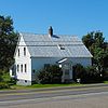 More images | |
| Cannon House | 10215 Highway 209 Diligent River NS | 45°24′46″N 64°27′27″W / 45.4127°N 64.4575°W / 45.4127; -64.4575 (Cannon House) | Nova Scotia (7814) | Upload Photo | |
| Chapman House National Historic Site of Canada | Chapman Road Fort Lawrence NS | 45°52′29″N 64°14′46″W / 45.8747°N 64.246°W / 45.8747; -64.246 (Chapman House National Historic Site of Canada) | Federal (7568) |  | |
| Church of the Good Shepherd | 842 Tidnish Head Road Tidnish Cross Roads NS | 45°59′38″N 64°00′38″W / 45.994°N 64.0106°W / 45.994; -64.0106 (Church of the Good Shepherd) | Tidnish Cross Roads municipality (11001) | Upload Photo | |
| 96 Church Street | 96 Church Street Amherst NS | 45°49′52″N 64°12′28″W / 45.8312°N 64.2079°W / 45.8312; -64.2079 (96 Church Street) | Amherst municipality (15306) | Upload Photo | |
| 150 Church Street | 150 Church Street Amherst NS | 45°49′43″N 64°12′06″W / 45.8285°N 64.2018°W / 45.8285; -64.2018 (150 Church Street) | Amherst municipality (8298) | Upload Photo | |
| Civic Building | 4030 Eastern Ave Parrsboro NS | 45°24′22″N 64°19′31″W / 45.4062°N 64.3252°W / 45.4062; -64.3252 (Civic Building) | Parrsboro municipality (7016) | 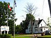 | |
| Coldspring Head Lighthouse | Lobster Cove Lane Northport NS | 45°57′45″N 63°51′55″W / 45.9625°N 63.8652°W / 45.9625; -63.8652 (Coldspring Head Lighthouse) | Federal (20772, (9682) | Upload Photo | |
| Davison-Kennedy House | 13440 Highway 6 Wallace Bay NS | 45°48′41″N 63°30′06″W / 45.8113°N 63.5016°W / 45.8113; -63.5016 (Davison-Kennedy House) | Wallace Bay municipality (11519) | Upload Photo | |
| Dewis House | 3291 Highway 209 Advocate Harbour NS | 45°20′40″N 64°47′59″W / 45.3444°N 64.7996°W / 45.3444; -64.7996 (Dewis House) | Advocate Harbour municipality (11319) | Upload Photo | |
| Fort Lawrence National Historic Site of Canada | Fort Lawrence Road Fort Lawrence NS | 45°50′52″N 64°15′42″W / 45.8478°N 64.2618°W / 45.8478; -64.2618 (Fort Lawrence National Historic Site of Canada) | Federal (13271) |  | |
| Fort Lawrence Terminus | Fort Lawrence Road; Route 4 Fort Lawrence NS | 45°50′24″N 64°16′01″W / 45.8401°N 64.267°W / 45.8401; -64.267 (Fort Lawrence Terminus) | Nova Scotia (7832) | 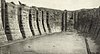 | |
| Hanna House | 5755 Highway 2 Lakelands NS | 45°29′18″N 64°21′02″W / 45.4883°N 64.3505°W / 45.4883; -64.3505 (Hanna House) | Lakelands municipality (11913) | Upload Photo | |
| 30 Hickman Street | 30 Hickman Street Amherst NS | 45°49′24″N 64°12′54″W / 45.8234°N 64.215°W / 45.8234; -64.215 (30 Hickman Street) | Amherst municipality (8259) | Upload Photo | |
| Howard House | 216 Fountain Road Middleboro NS | 45°45′10″N 63°34′07″W / 45.7529°N 63.5687°W / 45.7529; -63.5687 (Howard House) | Middleboro municipality (11318) | Upload Photo | |
| Joggins Fossil Cliffs | 100 Main St Joggins NS | 45°41′31″N 64°26′37″W / 45.6919°N 64.4436°W / 45.6919; -64.4436 (Joggins Fossil Cliffs) | Nova Scotia (14787) |  More images | |
| King Seaman Church | 5508 Barronsfield Road Minudie NS | 45°46′31″N 64°20′53″W / 45.7754°N 64.3481°W / 45.7754; -64.3481 (King Seaman Church) | Nova Scotia (7720), Minudie municipality (11253) | Upload Photo | |
| Lamp Cabin Building | 31 Industrial Park Drive Springhill NS | 45°38′42″N 64°03′52″W / 45.6451°N 64.0645°W / 45.6451; -64.0645 (Lamp Cabin Building) | Nova Scotia (9809) | Upload Photo | |
| Layton's General Store | 8724 No.2 Highway Great Village NS | 45°24′59″N 63°36′00″W / 45.4163°N 63.5999°W / 45.4163; -63.5999 (Layton's General Store) | Nova Scotia (3034) | Upload Photo | |
| Little Red Schoolhouse | 571 Highway 6 Amherst NS | 45°50′59″N 64°10′45″W / 45.8496°N 64.1792°W / 45.8496; -64.1792 (Little Red Schoolhouse) | Amherst municipality (11002) | Upload Photo | |
| Manning Block | 151 Main Street Parrsboro NS | 45°24′12″N 64°19′37″W / 45.4033°N 64.327°W / 45.4033; -64.327 (Manning Block) | Nova Scotia (6847) | Upload Photo | |
| Melville United Church Cemetery | 2036 Gulf Shore Road; RR #2 Pugwash NS | 45°31′19″N 63°20′09″W / 45.522°N 63.3358°W / 45.522; -63.3358 (Melville United Church Cemetery) | Pugwash municipality (11806) | Upload Photo | |
| Minudie School Museum | 5518 Barronsfield Road Minudie NS | 45°46′32″N 64°20′56″W / 45.7756°N 64.3488°W / 45.7756; -64.3488 (Minudie School Museum) | Nova Scotia (7723) | Upload Photo | |
| Mullins Point Upper Range Lighthouse | North Wallace Road North Wallace NS | 45°49′27″N 63°26′37″W / 45.8243°N 63.4435°W / 45.8243; -63.4435 (Mullins Point Upper Range Lighthouse) | Nova Scotia (7090) |  | |
| Nappan Experimental Farm, Cereal Forage Building | Highway 302 Nappan NS | 45°45′32″N 64°14′20″W / 45.759°N 64.239°W / 45.759; -64.239 (Nappan Experimental Farm, Cereal Forage Building) | Federal (2010) | Upload Photo | |
| Old Amherst Post Office | 50 Victoria Street East Amherst NS | 45°49′59″N 64°12′49″W / 45.8331°N 64.2136°W / 45.8331; -64.2136 (Old Amherst Post Office) | Nova Scotia (7268), Amherst municipality (8263) | Upload Photo | |
| Old Post Office | 50 Victoria Street East Parrsboro NS | 45°24′13″N 64°19′36″W / 45.4036°N 64.3267°W / 45.4036; -64.3267 (Old Post Office) | Parrsboro municipality (7017) | Upload Photo | |
| Ottawa House | 1155 Whitehall Road; Partridge Island Parrsboro NS | 45°22′31″N 64°19′46″W / 45.3752°N 64.3294°W / 45.3752; -64.3294 (Ottawa House) | Nova Scotia (13852), Parrsboro municipality (7019) |  | |
| Port Greville Lighthouse | 8334 Highway 209 Wards Brook NS | 45°24′51″N 64°33′13″W / 45.4143°N 64.5535°W / 45.4143; -64.5535 (Port Greville Lighthouse) | Wards Brook municipality (11321) | Upload Photo | |
| Pugwash Train Station | 10222 Durham Street Pugwash NS | 45°51′00″N 63°39′39″W / 45.85°N 63.6607°W / 45.85; -63.6607 (Pugwash Train Station) | Nova Scotia (14921), Pugwash municipality (11803) |  | |
| 1 Ratchford Street | 1 Ratchford Street Amherst NS | 45°50′03″N 64°12′40″W / 45.8342°N 64.2111°W / 45.8342; -64.2111 (1 Ratchford Street) | Amherst municipality (8275) | Upload Photo | |
| Renwick United Church | 6429 Highway 6 Linden NS | 45°52′45″N 63°50′11″W / 45.8791°N 63.8363°W / 45.8791; -63.8363 (Renwick United Church) | Linden municipality (15223) | Upload Photo | |
| River Philip United Church | 2808 Wyvern Road River Philip NS | 45°39′38″N 63°54′21″W / 45.6606°N 63.9058°W / 45.6606; -63.9058 (River Philip United Church) | River Philip municipality (11856) |  | |
| St. Andrew's Anglican Church | 13611 Highway 6 Wallace NS | 45°48′40″N 63°29′41″W / 45.811°N 63.4948°W / 45.811; -63.4948 (St. Andrew's Anglican Church) | Wallace municipality (11850) | Upload Photo | |
| St. Denis Church | 5534 Barronsfield Road Minudie NS | 45°46′32″N 64°21′00″W / 45.7756°N 64.3499°W / 45.7756; -64.3499 (St. Denis Church) | Nova Scotia (7264) | Upload Photo | |
| St. George's Anglican Church | 216 Main Street Parrsboro NS | 45°24′17″N 64°19′35″W / 45.4046°N 64.3263°W / 45.4046; -64.3263 (St. George's Anglican Church) | Parrsboro municipality (7018) |  More images | |
| St. James United Church | 8729 No. 2 Highway Great Village NS | 45°24′57″N 63°36′02″W / 45.4159°N 63.6005°W / 45.4159; -63.6005 (St. James United Church) | Nova Scotia (7267) | Upload Photo | |
| Saint Matthew's Presbyterian Church | 3863 No. 307 Highway Wallace NS | 45°48′45″N 63°28′24″W / 45.8126°N 63.4733°W / 45.8126; -63.4733 (Saint Matthew's Presbyterian Church) | Nova Scotia (8086) | Upload Photo | |
| Amos Thomas Seaman House | 5355 Barronsfield Road Minudie NS | 45°46′22″N 64°20′22″W / 45.7729°N 64.3395°W / 45.7729; -64.3395 (Amos Thomas Seaman House) | Nova Scotia (7815), Minudie municipality (11862) | Upload Photo | |
| Lorne Smith House | 11 Highway 302 Southampton NS | 45°35′47″N 64°14′54″W / 45.5963°N 64.2483°W / 45.5963; -64.2483 (Lorne Smith House) | Southampton municipality (11317) | Upload Photo | |
| Spencer's Island Lighthouse | Spencer's Beach Road Spencer's Island NS | 45°21′14″N 64°42′46″W / 45.354°N 64.7129°W / 45.354; -64.7129 (Spencer's Island Lighthouse) | Spencer's Island municipality (11808) |  | |
| Springhill Coal Mining National Historic Site of Canada | Corner of Industrial Park Dr and Memorial Crescent Springhill NS | 45°34′09″N 62°39′27″W / 45.5691°N 62.6574°W / 45.5691; -62.6574 (Springhill Coal Mining National Historic Site of Canada) | Federal (17988) |  | |
| Stone House | Gulf Shore Road Lower Gulf Shore NS | 45°52′30″N 63°31′22″W / 45.8749°N 63.5229°W / 45.8749; -63.5229 (Stone House) | Nova Scotia (7282) | Upload Photo | |
| Thinkers' Lodge National Historic Site of Canada | 247 Water Street Pugwash NS | 45°51′12″N 63°39′54″W / 45.8534°N 63.665°W / 45.8534; -63.665 (Thinkers' Lodge National Historic Site of Canada) | Federal (12561) |  | |
| Tidnish Bridge | Route 366 Tidnish Bridge NS | 45°58′34″N 64°02′37″W / 45.9762°N 64.0437°W / 45.9762; -64.0437 (Tidnish Bridge) | Nova Scotia (7831) | 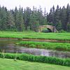 More images | |
| Tidnish Dock Site | Route 366 at Tidnish Cross Roads Tidnish NS | 45°59′52″N 64°00′28″W / 45.9978°N 64.0079°W / 45.9978; -64.0079 (Tidnish Dock Site) | Nova Scotia (7830) |  | |
| Trueman House | 2721 Highway 6 Truemanville NS | 45°51′52″N 64°03′00″W / 45.8645°N 64.0499°W / 45.8645; -64.0499 (Trueman House) | Truemanville municipality (11493) | Upload Photo | |
| Victoria | 177 Victoria Street Amherst NS | 45°50′16″N 64°12′22″W / 45.8379°N 64.2062°W / 45.8379; -64.2062 (Victoria) | Nova Scotia (7289), Amherst municipality (8257) | Upload Photo | |
| 54 Victoria Street East | 54 Victoria Street East Amherst NS | 45°50′00″N 64°12′47″W / 45.8333°N 64.2131°W / 45.8333; -64.2131 (54 Victoria Street East) | Amherst municipality (8258) | Upload Photo | |
| 60 Victoria Street East (Christ Church) | 60 Victoria Street East (Christ Church) Amherst NS | 45°50′00″N 64°12′47″W / 45.8333°N 64.2131°W / 45.8333; -64.2131 (60 Victoria Street East (Christ Church)) | Amherst municipality (8262) | Upload Photo | |
| 66 Victoria Street East (First Baptist Church) | 66 Victoria Street East (First Baptist Church) Amherst NS | 45°50′02″N 64°12′46″W / 45.8339°N 64.2128°W / 45.8339; -64.2128 (66 Victoria Street East (First Baptist Church)) | Amherst municipality (8260) |  | |
| 79 Victoria Street East (Bank of Nova Scotia) | 79 Victoria Street East (Bank of Nova Scotia) Amherst NS | 45°50′02″N 64°12′46″W / 45.8339°N 64.2127°W / 45.8339; -64.2127 (79 Victoria Street East (Bank of Nova Scotia)) | Amherst municipality (8261) | Upload Photo | |
| 91 Victoria Street East | 91 Victoria Street East Amherst NS | 45°50′03″N 64°12′45″W / 45.8342°N 64.2124°W / 45.8342; -64.2124 (91 Victoria Street East) | Amherst municipality (8256) | Upload Photo | |
| 100 Victoria Street East | 100 Victoria Street East Amherst NS | 45°50′04″N 64°12′45″W / 45.8344°N 64.2124°W / 45.8344; -64.2124 (100 Victoria Street East) | Amherst municipality (14801) | Upload Photo | |
| 233 Victoria Street East | 233 Victoria Street East Amherst NS | 45°50′28″N 64°11′55″W / 45.8412°N 64.1986°W / 45.8412; -64.1986 (233 Victoria Street East) | Amherst municipality (8255) | Upload Photo | |
| 27 Victoria Street West | 27 Victoria Street West Amherst NS | 45°49′58″N 64°12′48″W / 45.8328°N 64.2133°W / 45.8328; -64.2133 (27 Victoria Street West) | Amherst municipality (15656) | Upload Photo | |
| 46 Victoria Street West | 46 Victoria Street West Amherst NS | 45°49′40″N 64°12′58″W / 45.8278°N 64.2162°W / 45.8278; -64.2162 (46 Victoria Street West) | Amherst municipality (8254) | Upload Photo | |
| VIA Rail/Canadian National Railways Station | Station Street Amherst NS | 45°49′51″N 64°12′45″W / 45.8307°N 64.2125°W / 45.8307; -64.2125 (VIA Rail/Canadian National Railways Station (Amherst)) | Federal (4564) |  | |
| Wallace Harbour Sector Lighthouse | Sunrise Trail east of Wallace Wallace NS | 45°48′47″N 63°27′44″W / 45.8131°N 63.4621°W / 45.8131; -63.4621 (Wallace Harbour Sector Lighthouse) | Federal (21135) | Upload Photo | |
| Wallace River Railway Swing Bridge | Route 6 Wallace NS | 45°47′33″N 63°31′57″W / 45.7924°N 63.5325°W / 45.7924; -63.5325 (Wallace River Railway Swing Bridge) | Nova Scotia (6941) | Upload Photo | |
| Warren Baptist Church | 56 Cross Rd Hastings NS | 45°50′41″N 64°07′29″W / 45.8446°N 64.1246°W / 45.8446; -64.1246 (Warren Baptist Church) | Hastings municipality (11195) | Upload Photo | |
| Wentworth United Baptist Church | 13755 Highway 4 Wentworth NS | 45°38′46″N 63°33′04″W / 45.6461°N 63.5512°W / 45.6461; -63.5512 (Wentworth United Baptist Church) | Wentworth municipality (11315) | Upload Photo | |
| Wentworth Valley Schoolhouse | 80 Barclay Road Wentworth NS | 45°36′21″N 63°33′43″W / 45.6059°N 63.562°W / 45.6059; -63.562 (Wentworth Valley Schoolhouse) | Wentworth municipality (11316) | Upload Photo |
See also
Wikimedia Commons has media related to Cultural heritage monuments in Nova Scotia.
- List of historic places in Nova Scotia
- List of National Historic Sites of Canada in Nova Scotia
- Heritage Property Act (Nova Scotia)
- v
- t
- e
- CRHP
- Annapolis County
- Antigonish County
- Cape Breton RM
- Colchester County
- Cumberland County
- Digby County
- Guysborough County
- Halifax RM
- Hants County
- Inverness County
- Kings County
- Lunenburg County
- Pictou County
- Region of Queens Municipality
- Richmond County
- Shelburne County
- Victoria County
- Yarmouth County
- Acacia Grove / Prescott House
- Admiralty House
- Africville
- Akins House
- Alexander Graham Bell
- Annapolis County Court House
- Annapolis Royal Historic District
- Antigonish County Court House
- Argyle Township Court House and Jail
- Beaubassin
- Bedford Petroglyphs
- Beinn Bhreagh Hall
- Black-Binney House
- Bloody Creek
- Canso Islands
- Cast Iron Façade / Coomb's Old English Shoe Store
- Chapel Island
- Chapman House
- Charles Fort
- Covenaters' Church
- D'Anville's Encampment
- Debert Palaeo-Indian Site
- Fernwood
- Fort Anne
- Fort Edward
- Fort Lawrence
- Fort McNab
- Fort St. Louis
- Fort Sainte Marie de Grace
- Fortress of Louisbourg
- Georges Island
- Government House
- Grand-Pré & Grand-Pré Rural Historic District
- Granville Block
- Grassy Island Fort
- Halifax Citadel
- Halifax City Hall
- Halifax Court House
- Halifax Armoury
- Halifax Dockyard
- Halifax Public Gardens
- Halifax Waterfront Buildings
- Halifax WWII Coastal Defences
- Henry House
- HMCS Sackville
- Hydrostone District
- Jonathan McCully House
- Kejimkujik
- King's College
- Knaut–Rhuland House
- Ladies' Seminary
- Little Dutch (Deutsch) Church
- Liverpool Town Hall
- Lunenburg Academy
- Marconi & Marconi Wireless Station
- Melanson Settlement
- Melville Island & Deadman's Island
- Nova Scotia Coal Fields
- Old Barrington Meeting House
- Old Burying Ground
- Old Town Lunenburg Historic District
- Pictou Academy
- Pictou Railway Station (Intercolonial)
- Pier 21
- Port-Royal
- Prince of Wales Tower
- Province House
- Royal Battery
- SS Acadia
- Sainte-Anne / Port Dauphin
- Sinclair Inn / Farmer's Hotel
- Sir Frederick Borden Residence
- Springhill Coal Mining
- St. George's Anglican Church / Round Church
- St. John's Anglican Church
- St. Mary's Basilica
- St. Paul's Anglican Church
- St. Peter's
- St. Peters Canal
- Sydney WWII Coastal Defences
- Thinkers' Lodge
- Trinity Anglican Church
- Truro Old Normal College
- Truro Post Office
- Wolfe's Landing
- York Redoubt
areas & others
 Category
 Commons
 Canada portal


