Lamgong Gewog
Gewogs in Paro District, Bhutan
Lamgong Gewog ལམ་གོང་ | |
|---|---|
Gewogs | |
 | |
| Country |  Bhutan Bhutan |
| District | Paro District |
| Time zone | UTC+6 (BTT) |
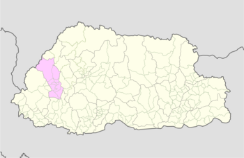
Lamgong Gewog (Dzongkha: ལམ་གོང་) is a gewog (village block) of Paro District, Bhutan.[1] The gewog had an area of 48.8 square kilometres in 2002, and contained eight villages and 348 households.[2]
References
- v
- t
- e
Village groups (gewogs) of Bhutan
Bhutan Zone
| Dagana District |
|
|---|---|
| Gasa District | |
| Punakha District | |
| Tsirang District | |
| Wangdue Phodrang District |

Bhutan Zone
| Bumthang District | |
|---|---|
| Sarpang District | |
| Trongsa District | |
| Zhemgang District |
Bhutan Zone
| Chukha District | |
|---|---|
| Haa District | |
| Paro District | |
| Samtse District | |
| Thimphu District |
Bhutan Zone
| Lhuntse District | |
|---|---|
| Mongar District | |
| Pemagatshel District | |
| Samdrup Jongkhar District | |
| Trashigang District | |
| Trashiyangtse District |
| Dagana District | |
|---|---|
| Chukha District | |
| Pemagatshel District | |
| Samtse District | |
| Sarpang District | |
| Thimphu District | |
| Tsirang District | |
| Samdrup Jongkhar District |
 | This Bhutan location article is a stub. You can help Wikipedia by expanding it. |
- v
- t
- e


