Kungsbacka Municipality
Municipality in Halland County, Sweden
Kungsbacka Municipality Kungsbacka kommun | |
|---|---|
Municipality | |
 | |
 Coat of arms | |
 | |
| Coordinates: 57°29′N 12°04′E / 57.483°N 12.067°E / 57.483; 12.067 | |
| Country | Sweden |
| County | Halland County |
| Seat | Kungsbacka |
| Area | |
| • Total | 1,472.94 km2 (568.71 sq mi) |
| • Land | 606.67 km2 (234.24 sq mi) |
| • Water | 866.27 km2 (334.47 sq mi) |
| Area as of 1 January 2014. | |
| Population (31 December 2023)[2] | |
| • Total | 85,653 |
| • Density | 58/km2 (150/sq mi) |
| Time zone | UTC+1 (CET) |
| • Summer (DST) | UTC+2 (CEST) |
| ISO 3166 code | SE |
| Province | Halland |
| Municipal code | 1384 |
| Website | www.kungsbacka.se |
| Density is calculated using land area only. | |
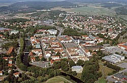
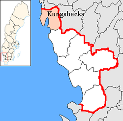
Kungsbacka Municipality (Kungsbacka kommun) is a municipality in Halland County on the Swedish west coast, some 30 km south of Gothenburg. The municipal seat is located in the town Kungsbacka.
In 1969 Tölö was merged into the City of Kungsbacka. In 1971 the municipality was created when the city amalgamated with Särö. The final step was taken in 1974 when three more former municipalities were added to form the new entity.
Kungsbacka Municipality is closely integrated in the region of Metropolitan Gothenburg, but despite this it is administratively not a part of Västra Götaland County like the rest of the region.
A local geographical landmark is the glacial ridge Fjärås bräcka, to the south of Kungsbacka, but it is the coast that is the predominant geographical feature. The municipality receives its drinking water from the nearby lake Lygnern; the water undergoes a natural filtering process as it trickles through the ridge, contributing to its quality.
Localities
There are 22 urban areas (also called a tätort or locality) in Kungsbacka Municipality.
In the table the localities are listed according to the size of the population as of 31 December 2005. The municipal seat is in bold characters.
| # | Locality | Population |
|---|---|---|
| 1 | Kungsbacka | 17,784 |
| 2 | Onsala | 11,375 |
| 3 | Billdal 1) | 9,609 |
| 4 | Åsa | 3,218 |
| 5 | Särö | 2,982 |
| 6 | Fjärås kyrkby | 2,213 |
| 7 | Frillesås 2) | 1,924 |
| 8 | Backa | 1,516 |
| 9 | Vallda | 1,439 |
| 10 | Anneberg | 1,398 |
| 11 | Västra Hagen | 810 |
| 12 | Ölmanäs | 787 |
| 13 | Buerås | 556 |
| 14 | Halla Heberg | 509 |
| 15 | Lerkil | 411 |
| 16 | Gundal och Högås | 363 |
| 17 | Hagryd-Dala | 355 |
| 18 | Hjälmared | 341 |
| 19 | Brattås | 339 |
| 20 | Kläppa | 298 |
| 21 | Hjälm | 251 |
| 22 | Röda Holme | 201 |
1) Billdal is a bimunicipal [1][permanent dead link] locality. About 3,000 of the inhabitants are in Gothenburg Municipality.
2) A minor part of Frillesås is in Varberg Municipality.
Demographics
This is a demographic table based on Kungsbacka Municipality's electoral districts in the 2022 Swedish general election sourced from SVT's election platform, in turn taken from SCB official statistics.[3]
In total there were 83,376 residents, including 64,298 Swedish citizens of voting age.[3] 34.6% voted for the left coalition and 64.4% for the right coalition. The right coalition won all 46 electoral districts in the municipality, making Kungsbacka the largest municipality in Sweden where this occurred. Indicators are in percentage points except population totals and income.
| Location | Residents | Citizen adults | Left vote | Right vote | Employed | Swedish parents | Foreign heritage | Income SEK | Degree |
|---|---|---|---|---|---|---|---|---|---|
| % | % | ||||||||
| Anneberg | 1,854 | 1,369 | 39.8 | 59.0 | 89 | 91 | 9 | 31,316 | 54 |
| Björkris | 2,051 | 1,277 | 36.7 | 61.3 | 79 | 75 | 25 | 27,708 | 46 |
| Bukärr C | 2,348 | 1,787 | 25.6 | 73.1 | 85 | 90 | 10 | 35,463 | 65 |
| Fjärås N | 2,315 | 1,694 | 39.0 | 59.7 | 86 | 87 | 13 | 28,524 | 38 |
| Fjärås S | 1,748 | 1,233 | 33.3 | 65.4 | 88 | 88 | 12 | 29,054 | 37 |
| Fjärås/Må | 2,292 | 1,603 | 39.8 | 59.2 | 86 | 86 | 14 | 27,044 | 40 |
| Fors | 1,587 | 1,179 | 42.5 | 56.4 | 88 | 93 | 7 | 33,146 | 61 |
| Forsbäck/Oskarsberg | 2,558 | 1,887 | 29.3 | 70.5 | 89 | 90 | 10 | 36,565 | 60 |
| Frillesås Kust | 1,971 | 1,447 | 40.9 | 58.0 | 85 | 91 | 9 | 29,727 | 50 |
| Frillesås Landsbygd | 2,055 | 1,488 | 39.2 | 58.8 | 87 | 90 | 10 | 29,008 | 36 |
| Gottskär | 1,555 | 1,232 | 24.3 | 74.7 | 86 | 91 | 9 | 34,377 | 59 |
| Gällinge/Idala | 1,931 | 1,474 | 37.3 | 61.5 | 87 | 91 | 9 | 27,617 | 33 |
| Hammerö | 1,414 | 1,104 | 38.2 | 60.0 | 81 | 80 | 20 | 25,739 | 44 |
| Hammerö S/V | 1,624 | 1,251 | 35.3 | 63.5 | 83 | 85 | 15 | 27,796 | 48 |
| Hanhals | 1,351 | 1,014 | 36.1 | 63.2 | 88 | 91 | 9 | 29,896 | 42 |
| Hede | 1,624 | 1,187 | 43.0 | 56.5 | 87 | 90 | 10 | 30,598 | 54 |
| Hålabäck | 1,925 | 1,496 | 41.4 | 57.1 | 84 | 83 | 17 | 26,594 | 41 |
| Innerstaden | 1,258 | 1,149 | 32.3 | 66.3 | 83 | 86 | 14 | 27,877 | 36 |
| Kolla N | 1,444 | 1,175 | 36.1 | 63.4 | 90 | 88 | 12 | 30,641 | 56 |
| Kolla S | 1,189 | 909 | 32.1 | 67.0 | 91 | 89 | 11 | 31,697 | 50 |
| Kullavik C | 1,840 | 1,439 | 30.2 | 69.4 | 86 | 89 | 11 | 34,309 | 61 |
| Kyvik | 2,104 | 1,590 | 23.3 | 76.3 | 83 | 91 | 9 | 39,605 | 72 |
| Malevik/Släps Inland | 2,153 | 1,578 | 28.6 | 70.7 | 87 | 89 | 11 | 35,609 | 60 |
| Onsala Kyrka | 2,010 | 1,553 | 31.5 | 67.1 | 85 | 89 | 11 | 32,536 | 56 |
| Onsala Rydet | 1,912 | 1,430 | 29.8 | 69.1 | 90 | 90 | 10 | 33,736 | 55 |
| Presse/Skällared | 2,169 | 1,563 | 31.8 | 67.5 | 92 | 91 | 9 | 34,060 | 56 |
| Släps Kullen | 2,307 | 1,765 | 22.0 | 77.5 | 85 | 91 | 9 | 44,611 | 73 |
| Särö | 1,905 | 1,461 | 23.8 | 75.2 | 84 | 88 | 12 | 34,947 | 59 |
| Södra Onsala | 1,376 | 1,064 | 29.0 | 69.9 | 84 | 90 | 10 | 34,683 | 60 |
| Tingberget | 1,324 | 1,149 | 39.1 | 59.8 | 84 | 83 | 17 | 25,350 | 41 |
| Tölö | 1,935 | 1,292 | 38.6 | 60.4 | 90 | 88 | 12 | 33,493 | 56 |
| Vallda Backa | 2,003 | 1,471 | 38.0 | 61.6 | 89 | 93 | 7 | 31,167 | 51 |
| Vallda Bröndome | 1,529 | 1,126 | 31.2 | 66.8 | 88 | 89 | 11 | 30,223 | 44 |
| Vallda Lerkil | 1,886 | 1,442 | 31.2 | 68.3 | 87 | 91 | 9 | 32,375 | 50 |
| Vallda Sandö | 1,892 | 1,401 | 34.2 | 64.9 | 89 | 92 | 8 | 35,096 | 62 |
| Varla N | 2,181 | 1,711 | 38.1 | 61.5 | 85 | 86 | 14 | 28,780 | 49 |
| Varla S | 2,039 | 1,625 | 44.4 | 53.9 | 80 | 80 | 20 | 23,296 | 31 |
| Vässingö/Röda Holme | 1,613 | 1,282 | 33.5 | 65.7 | 89 | 91 | 9 | 31,956 | 58 |
| Västra Onsala | 2,439 | 1,806 | 33.5 | 65.4 | 89 | 92 | 8 | 31,570 | 45 |
| Västra Villastaden | 1,584 | 1,263 | 39.1 | 60.5 | 83 | 85 | 15 | 27,602 | 44 |
| Åsa C | 2,013 | 1,521 | 40.6 | 58.1 | 85 | 89 | 11 | 27,610 | 44 |
| Åsa Kust | 1,499 | 1,223 | 34.4 | 64.4 | 82 | 89 | 11 | 32,071 | 54 |
| Älvsåker | 1,862 | 1,387 | 39.0 | 59.4 | 89 | 90 | 10 | 31,023 | 41 |
| Ö Villastaden | 1,857 | 1,535 | 39.5 | 59.1 | 84 | 91 | 9 | 28,011 | 50 |
| Ölmanäs | 1,850 | 1,418 | 34.2 | 64.6 | 89 | 93 | 7 | 33,388 | 61 |
| Ölmevalla Ö | 1,828 | 1,248 | 39.8 | 59.6 | 86 | 87 | 13 | 31,244 | 46 |
| Source: SVT[3] | |||||||||
References
- ^ "Statistiska centralbyrån, Kommunarealer den 1 januari 2014" (in Swedish). Statistics Sweden. 2014-01-01. Archived from the original (Microsoft Excel) on 2016-09-27. Retrieved 2014-04-18.
- ^ "Folkmängd och befolkningsförändringar - Kvartal 4, 2023" (in Swedish). Statistics Sweden. February 22, 2024. Retrieved February 22, 2024.
- ^ a b c "Valresultat 2022 för Kungsbacka i riksdagsvalet" (in Swedish). SVT. 11 September 2022. Retrieved 4 February 2024.
External links
Wikimedia Commons has media related to Kungsbacka Municipality.
- Kungsbacka Municipality - Official site
Places adjacent to Kungsbacka Municipality | ||||||||||||||||
|---|---|---|---|---|---|---|---|---|---|---|---|---|---|---|---|---|
| ||||||||||||||||


- v
- t
- e
Municipalities and seats of Halland County
- Falkenberg
- Halmstad
- Hylte
- Kungsbacka
- Laholm
- Varberg

Authority control databases | |
|---|---|
| International |
|
| National |
|
| Geographic |
|


