Karlshuld
Municipality in Bavaria, Germany

Coat of arms
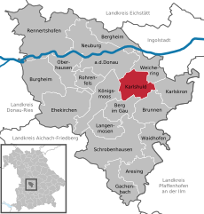
Location of Karlshuld within Neuburg-Schrobenhausen district
(2020–26) Michael Lederer[1] (FW)
(2022-12-31)[2]
86668
Karlshuld is a municipality in the district of Neuburg-Schrobenhausen in Bavaria in Germany.
History
The locality was created in the course of the draining of the Donaumooses begun at 1790, in the year 1795 it became a colony of Karl Freiherr v. Eckart and was named after Charles Theodore, Elector of Bavaria. The place was until 1840 seat of an aristocracy yard Mark (and/or a Patrimonialgerichts). 1804 had five times more than originally planned, already over 300 inhabitants. The living conditions were in particular in the beginning, very hard, and improved in the course of the decades only little. 1824 were created a little later again a closed spinning mill, 1898 developed the moorland laboratory. 1888 gave it already 1,227 inhabitants. The place kept courses of a distressed area, until the Second World War when, like in many places, a fundamental upswing began.
Today Karlshuld is a prosperous municipality, which won in the last years also as residence - not least due to the proximity to Ingolstadt - at attractiveness.
In the years 1970 to 1985 took place the incorporations of the municipality parts Grasheim, Kochheim, Nazibühl and Neuschwetzingen.
References
- ^ Liste der ersten Bürgermeister/Oberbürgermeister in kreisangehörigen Gemeinden, Bayerisches Landesamt für Statistik, 15 July 2021.
- ^ Genesis Online-Datenbank des Bayerischen Landesamtes für Statistik Tabelle 12411-003r Fortschreibung des Bevölkerungsstandes: Gemeinden, Stichtag (Einwohnerzahlen auf Grundlage des Zensus 2011).
- v
- t
- e
Towns and municipalities in Neuburg-Schrobenhausen
- Aresing
- Berg im Gau
- Bergheim
- Brunnen
- Burgheim
- Ehekirchen
- Gachenbach
- Karlshuld
- Karlskron
- Königsmoos
- Langenmosen
- Neuburg an der Donau
- Oberhausen
- Rennertshofen
- Rohrenfels
- Schrobenhausen
- Waidhofen
- Weichering

Authority control databases | |
|---|---|
| International |
|
| National |
|
 | This Neuburg-Schrobenhausen location article is a stub. You can help Wikipedia by expanding it. |
- v
- t
- e


