Kandovan, Osku
Village in East Azerbaijan, Iran
Kandovan كندوان | |
|---|---|
Village | |
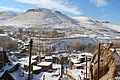
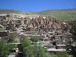 A view of Kandovan's rock houses | |
| 37°47′42″N 46°14′55″E / 37.79500°N 46.24861°E / 37.79500; 46.24861 | |
| Country |  Iran Iran |
| Province | East Azerbaijan |
| County | Osku |
| Bakhsh | Central |
| Rural District | Sahand |
| Population (2006) | |
| • Total | 601 |
| Time zone | UTC+3:30 (IRST) |
| • Summer (DST) | UTC+4:30 (IRDT) |
Kandovan (Persian: كندوان, also romanized as Kandovān and Kandavān; also known as Kanvān)[1] is an ancient village in Sahand Rural District in the Central District of Osku County, East Azerbaijan Province, northwestern Iran. It is situated in the foothills of Mount Sahand, near the city of Osku. At the 2006 census, the village population was 601, in 168 families.[2]
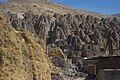
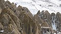
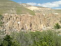
The village exemplifies manmade cliff dwellings which are still inhabited. The troglodyte homes, excavated inside volcanic rocks similar to dwellings in the Turkish region of Cappadocia, are locally called Karaan.[3] Karaans were cut into non-welded ignimbrites, also called "ash-flow tuffs," of Mount Sahand. The cone form of the houses is the result of the erosion of ignimbrite layers consisting of porous, round and angular pumice together with other volcanic particles that were positioned in a grey, acidic matrix. During the eruption of Sahand, pyroclastic flows formed the rocks of Kandovan. Around the village the thickness of this formation exceeds 100 metres (330 ft) and with time, due to water erosion, the cone-shaped cliffs were formed.[4]
Origin and stages of development
Mount Sahand is one of the most important mountains, the Silent volcano in Iran for one hundred and forty thousand years ago, After the retreat of Kandovan Lake basin, The stone of Kandovan has appeared. There are several narrations about the causes of the emergence of the village:
- The original inhabitants were nomads who had previously been Condon this place was used as a summer house and houses dug inside the rocks, as a house they used it temporarily to reduce the hassle of moving later have settled there.
- Primary residents of Kandovan village, residents of the ruined and ancient village was "Hilevar". Those times Mongol attack from this village, which is about two kilometers It is far from Kandovan, they had moved and lived in Kandovan .
- In ancient times, some of the warriors from this place passed, due to the better military position of the place, Especially its topographic position that penetrates from above makes the domain impossible, use it as its own refuge they chose and started digging houses inside the rocks.[5]
Gallery
-
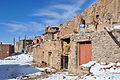
 Far view of a hotel on the left and the rock houses on the right
 -
 Closer view of the village
 -
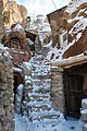 In the village
 -
 In the village
 -
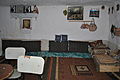 Interior of a traditional home
 -
 View of the village and surroundings from the rock houses
 -
-

-
-

-

-


References
- ^ Kandavan can be found at GEOnet Names Server, at this link, by opening the Advanced Search box, entering "-3813310" in the "Unique Feature Id" form, and clicking on "Search Database".
- ^ "Census of the Islamic Republic of Iran, 1385 (2006)" (Excel). Statistical Center of Iran. Archived from the original on 2011-09-20.
- ^ Hashemi, S., 2013. The Magnificence of Civilization in Depths of Ground (A Review of Underground Structures in Iran – Past to Present), Shadrang Printing and Publishing Co., Tehran.
- ^ Kaljahi, E.A., Birami, F.A. and Hajialilue, M., 2015. Influence of Geological Structures and Weathering in Formation and Destruction of Cone-Shaped Rocky Houses of the Kandovan Village, Iran. In Engineering Geology for Society and Territory-Volume 8 (pp. 231-234). Springer, Cham.
- ^ Yusef Gorji Mehlabani and Elmira Saanayi, Rural Architecture, Architecture in harmony with the cimate of Kandovan, 2009 , Housing and Rural environment
External links
- "Cones of Kandovan", JadidOnline.com
- "Kandovan: A Rocky Village Life in Iran", Amazingiran.media
 Iran portal

Wikimedia Commons has media related to Kandovan.
- v
- t
- e
Tabriz landmarks
- Madrasah Akbarieh
- American Memorial School in Tabriz
- Mansur High School
- Azarbaijan Shahid Madani University
- Sahand University of Technology
- Tabriz University of Medical Sciences
- University of Tabriz
- Tabriz Islamic Arts University
- Islamic Azad University, Tabriz Science and Research Branch
- Islamic Azad University of Tabriz
- Tabriz Technical College
- Shahid Qasem Soleimani Stadium
- Yadegar-e Emam Stadium
- Takhti Stadium
- Marzdaran Stadium
- Tractor Stadium
- Shahid Poursharifi Arena
- Tabriz Cycling Track
- Tractor Sazi F.C. Academy
- Sahand Ski Resort
Category:Tabriz
| |||||||||||||||||||||||
|---|---|---|---|---|---|---|---|---|---|---|---|---|---|---|---|---|---|---|---|---|---|---|---|
| Capital | |||||||||||||||||||||||
| Districts |
| ||||||||||||||||||||||
 | This Osku County location article is a stub. You can help Wikipedia by expanding it. |
- v
- t
- e


