Javorani, Kneževo
Place in Republika Srpska, Bosnia and Herzegovina
44°37′N 17°15′E / 44.617°N 17.250°E / 44.617; 17.250 (1991)
78233
Javorani (Cyrillic: Јаворани), is a village in Kneževo (Skender Vakuf) municipality, near Banja Luka, Republika Srpska, Bosnia and Herzegovina.
History
Until 1955, Javorani belonged to the former Previle Municipality, Kotor Varoš.
Population
Ethnic composition, 1991 census
| Ethnic composition of Skender Vakuf municipality, by settlements, 1991. census | ||||||
| settlement | total | Serbs | Croats | Muslims | Yugoslavs | others |
| Javorani | 1,289 | 1,273 | 1 | 0 | 6 | 9 |
References
- Official results from the book: Ethnic composition of Bosnia-Herzegovina population, by municipalities and settlements, 1991. census, Zavod za statistiku Bosne i Hercegovine - Bilten no.234, Sarajevo 1991.
Gallery
-
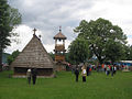 Old St. Nicholas Church from 1757.
 -
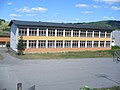 New Primary school in Javorani.
 -
 Old Primary school in Javorani.
 -
![Mountain Tisovac [sr].](//upload.wikimedia.org/wikipedia/commons/thumb/4/40/%D0%9F%D0%BB%D0%B0%D0%BD%D0%B8%D0%BD%D0%B0_%D0%A2%D0%B8%D1%81%D0%BE%D0%B2%D0%B0%D1%86_%28%D0%88%D0%B0%D0%B2%D0%BE%D1%80%D0%B0%D0%BD%D0%B8%29.jpg/120px-%D0%9F%D0%BB%D0%B0%D0%BD%D0%B8%D0%BD%D0%B0_%D0%A2%D0%B8%D1%81%D0%BE%D0%B2%D0%B0%D1%86_%28%D0%88%D0%B0%D0%B2%D0%BE%D1%80%D0%B0%D0%BD%D0%B8%29.jpg) Mountain Tisovac [sr].
Mountain Tisovac [sr]. -
 River Kotlovac.
 -
 Winter in Javorani.
 -
 Landscape in Javorani.


![Mountain Tisovac [sr].](http://upload.wikimedia.org/wikipedia/commons/thumb/4/40/%D0%9F%D0%BB%D0%B0%D0%BD%D0%B8%D0%BD%D0%B0_%D0%A2%D0%B8%D1%81%D0%BE%D0%B2%D0%B0%D1%86_%28%D0%88%D0%B0%D0%B2%D0%BE%D1%80%D0%B0%D0%BD%D0%B8%29.jpg/120px-%D0%9F%D0%BB%D0%B0%D0%BD%D0%B8%D0%BD%D0%B0_%D0%A2%D0%B8%D1%81%D0%BE%D0%B2%D0%B0%D1%86_%28%D0%88%D0%B0%D0%B2%D0%BE%D1%80%D0%B0%D0%BD%D0%B8%29.jpg)


People from Javorani
- Lazar Tešanović - One of the Chetniks leader in Bosnia during World War II.
See also
External links
Map of Javorani
Wikimedia Commons has media related to Javorani.
- v
- t
- e
- Bastaji
- Bekići
- Bokani
- Borak
- Bregovi
- Vlatkovići
- Golo Brdo
- Gornji Korićani
- Doline
- Donji Korićani, Živinice
- Imljani, Javorani
- Kneževo
- Kobilja
- Korićani
- Kostići
- Milovići
- Mokri Lug
- Pavlovići
- Paunovići
- Ravni Sto
- Rađići
- Ćeleši
- Ćukovac
- Čarići
- Šolaji


