Grade II* listed buildings in Elmbridge

Map all coordinates using OpenStreetMap
Download coordinates as:
- KML
- GPX (all coordinates)
- GPX (primary coordinates)
- GPX (secondary coordinates)
There are over 20,000 Grade II* listed buildings in England. This page is a list of the 23 Grade II* listed buildings in the district of Elmbridge in Surrey. For links to similar articles in relation to the other 10 districts of Surrey see Grade II* listed buildings in Surrey.
| Name | Location | Type | Completed [note 1] | Date designated | Grid ref.[note 2] Geo-coordinates | Entry number [note 3] | Image |
|---|---|---|---|---|---|---|---|
| Barn at Upper Manor Farm, 40 Yards South of Number 81 (the Rectory) | Stoke D'Abernon | Barn | 19th century | 10 December 1981 | TQ1297058707 51°18′59″N 0°22′49″W / 51.316267°N 0.380385°W / 51.316267; -0.380385 (Barn at Upper Manor Farm, 40 Yards South of Number 81 (the Rectory)) | 1030109 |  Upload Photo |
| Benfleet Hall | Cobham | House | 1860 | 4 February 1963 | TQ1226461379 51°20′26″N 0°23′23″W / 51.340423°N 0.38967°W / 51.340423; -0.38967 (Benfleet Hall) | 1189134 | Upload Photo |
| Cedar House | Cobham | House | Mid 18th century | 14 August 1953 | TQ1112559932 51°19′40″N 0°24′23″W / 51.32764°N 0.406466°W / 51.32764; -0.406466 (Cedar House) | 1365901 | Upload Photo |
| Chatley Semaphore Tower | Cobham | Tower | 1822 | 14 August 1953 | TQ0894258506 51°18′55″N 0°26′18″W / 51.315245°N 0.43822°W / 51.315245; -0.43822 (Chatley Semaphore Tower) | 1286699 | 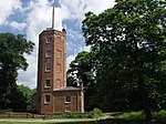 More images |
| Church of St Charles Borromeo with attached Presbyteries | Weybridge | Chapel and Priest's House | c. 1834 | 10 February 1977 | TQ0731064167 51°21′59″N 0°27′36″W / 51.366438°N 0.459923°W / 51.366438; -0.459923 (Church of St Charles Borromeo with attached Presbyteries) | 1189164 |  More images |
| Church of St James | Weybridge | Church | 1848 | 19 October 1951 | TQ0722164736 51°22′18″N 0°27′40″W / 51.37157°N 0.46103°W / 51.37157; -0.46103 (Church of St James) | 1188363 |  More images |
| Church Stile House | Cobham | House | 18th century | 14 August 1953 | TQ1078959810 51°19′36″N 0°24′41″W / 51.326609°N 0.411324°W / 51.326609; -0.411324 (Church Stile House) | 1294922 | 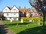 More images |
| Former Kitchen Garden Walls to Claremont House | Esher | Garden Wall | c. 1720 | 16 November 1984 | TQ1373963631 51°21′37″N 0°22′04″W / 51.360371°N 0.367784°W / 51.360371; -0.367784 (Former Kitchen Garden Walls to Claremont House) | 1377465 | Upload Photo |
| Ham Manor | Cobham | House | Mid 18th century | 14 August 1953 | TQ1102459911 51°19′39″N 0°24′29″W / 51.327471°N 0.407921°W / 51.327471; -0.407921 (Ham Manor) | 1365900 | Upload Photo |
| Henry Bridge's Almshouses | Thames Ditton | House | 1720 | 14 August 1953 | TQ1568866945 51°23′23″N 0°20′19″W / 51.389764°N 0.338726°W / 51.389764; -0.338726 (Henry Bridge's Almshouses) | 1030105 | 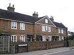 More images |
| Home Farm House and Barns | Cobham | Farmhouse | c. 1860 | 10 October 1975 | TQ0792060766 51°20′09″N 0°27′08″W / 51.335753°N 0.452195°W / 51.335753; -0.452195 (Home Farm House and Barns) | 1377473 | Upload Photo |
| Home of Compassion | Thames Ditton | House | c. 1786 | 14 August 1953 | TQ1620267222 51°23′32″N 0°19′53″W / 51.39215°N 0.33125°W / 51.39215; -0.33125 (Home of Compassion) | 1030197 |  More images |
| Milestone | Esher | Milestone | 1747 | 28 May 1969 | TQ1342462971 51°21′16″N 0°22′21″W / 51.354502°N 0.372516°W / 51.354502; -0.372516 (Milestone) | 1377464 | Upload Photo |
| Newlands | Weston Green | House | Late 17th century | 14 August 1953 | TQ1534866387 51°23′05″N 0°20′38″W / 51.384817°N 0.343791°W / 51.384817; -0.343791 (Newlands) | 1030088 | Upload Photo |
| Obelisk 10 Yards to Rear of Number 6 (Home Farm House) | Esher | Obelisk | Early 18th century | 14 August 1953 | TQ1386763673 51°21′39″N 0°21′57″W / 51.360723°N 0.365933°W / 51.360723; -0.365933 (Obelisk 10 Yards to Rear of Number 6 (Home Farm House)) | 1190801 | Upload Photo |
| Painshill House | Cobham | House | 1778 | 17 March 1982 | TQ0972760351 51°19′54″N 0°25′35″W / 51.331678°N 0.426393°W / 51.331678; -0.426393 (Painshill House) | 1030132 | Upload Photo |
| Parkside School | Stoke D'Abernon | House | c. 1760 | 16 November 1984 | TQ1304558462 51°18′51″N 0°22′46″W / 51.31405°N 0.379386°W / 51.31405; -0.379386 (Parkside School) | 1030110 |  |
| The Belvedere, 250 Yards South West of Claremont House | Esher | Belvedere | c. 1716 | 14 August 1953 | TQ1331163286 51°21′26″N 0°22′27″W / 51.357356°N 0.374038°W / 51.357356; -0.374038 (The Belvedere, 250 Yards South West of Claremont House) | 1030204 | 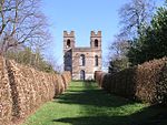 More images |
| The Clubhouse, Brooklands Museum | Weybridge | Restaurant | 1906-1907 | 1 November 2002 | TQ0703262839 51°21′16″N 0°27′52″W / 51.354554°N 0.464314°W / 51.354554; -0.464314 (The Clubhouse, Brooklands Museum) | 1272443 |  More images |
| The Elms | Weston Green | House | Early 18th century | 14 August 1953 | TQ1517166284 51°23′02″N 0°20′47″W / 51.383928°N 0.346367°W / 51.383928; -0.346367 (The Elms) | 1030087 | Upload Photo |
| The Gothic Temple | Cobham | Garden Temple | Late 18th century | 16 November 1984 | TQ0966860032 51°19′44″N 0°25′38″W / 51.328822°N 0.427338°W / 51.328822; -0.427338 (The Gothic Temple) | 1030124 | 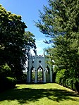 More images |
| The Gothic Tower | Cobham | Prospect Tower | Mid 19th century | 9 April 1973 | TQ0850759782 51°19′36″N 0°26′39″W / 51.326797°N 0.444071°W / 51.326797; -0.444071 (The Gothic Tower) | 1191694 | 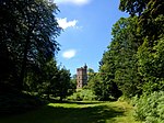 More images |
| White Cottage | Esher | House | c. 1720 | 28 May 1969 | TQ1357063503 51°21′33″N 0°22′13″W / 51.359254°N 0.370251°W / 51.359254; -0.370251 (White Cottage) | 1377463 | Upload Photo |
Notes
- ^ The date given is the date used by Historic England as significant for the initial building or that of an important part in the structure's description.
- ^ Sometimes known as OSGB36, the grid reference is based on the British national grid reference system used by the Ordnance Survey.
- ^ The "List Entry Number" is a unique number assigned to each listed building and scheduled monument by Historic England.
References
English Heritage Images of England
External links
- v
- t
- e
- Bedfordshire
- Berkshire
- Bristol
- Buckinghamshire
- Cambridgeshire
- Cheshire
- Cornwall
- Cumbria
- Derbyshire
- Devon
- Dorset
- Durham
- East Sussex
- East Riding of Yorkshire
- Essex
- Gloucestershire
- Greater London
- Greater Manchester
- Hampshire
- Herefordshire
- Hertfordshire
- Isle of Wight
- Kent
- Lancashire
- Leicestershire
- Lincolnshire
- Merseyside
- Norfolk
- North Yorkshire
- Northamptonshire
- Northumberland
- Nottinghamshire
- Oxfordshire
- Rutland
- Shropshire
- Somerset
- South Yorkshire
- Staffordshire
- Suffolk
- Surrey
- Tyne and Wear
- Warwickshire
- West Midlands
- West Sussex
- West Yorkshire
- Wiltshire
- Worcestershire
- Allerdale
- Amber Valley
- Ashford
- Babergh
- Barrow-in-Furness
- Basildon
- Basingstoke and Deane
- Bath and North East Somerset
- Bolsover
- Boston
- Bournemouth
- Bradford
- Braintree
- Breckland
- Brentwood
- Brighton and Hove
- Bristol
- Broadland
- Calderdale
- Cambridge
- Camden
- Canterbury
- Carlisle
- Castle Point
- Chelmsford
- Cheltenham
- Cherwell
- Cheshire East
- Cheshire West and Chester
- Chesterfield
- Chiltern
- Christchurch
- Colchester
- Copeland
- Corby
- Cotswold
- Craven
- Dartford
- Daventry
- Dover
- East Cambridgeshire
- Exeter
- Mendip
- North Somerset
- Poole
- Sedgemoor
- South Somerset
- Stoke-on-Trent
- Taunton Deane
- West Somerset
- York


