Goryōkaku
Star fort in Hakodate, Japan
You can help expand this article with text translated from the corresponding article in Japanese. (January 2021) Click [show] for important translation instructions.
- View a machine-translated version of the Japanese article.
- Machine translation, like DeepL or Google Translate, is a useful starting point for translations, but translators must revise errors as necessary and confirm that the translation is accurate, rather than simply copy-pasting machine-translated text into the English Wikipedia.
- Consider adding a topic to this template: there are already 3,691 articles in the main category, and specifying
|topic=will aid in categorization. - Do not translate text that appears unreliable or low-quality. If possible, verify the text with references provided in the foreign-language article.
- You must provide copyright attribution in the edit summary accompanying your translation by providing an interlanguage link to the source of your translation. A model attribution edit summary is
Content in this edit is translated from the existing Japanese Wikipedia article at [[:ja:五稜郭]]; see its history for attribution. - You may also add the template
{{Translated|ja|五稜郭}}to the talk page. - For more guidance, see Wikipedia:Translation.
41°47′49″N 140°45′25″E / 41.79694°N 140.75694°E / 41.79694; 140.75694
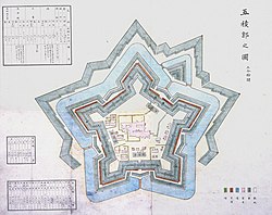
19th century map of Goryōkaku
Goryōkaku (五稜郭, lit. 'five-point fort') is a star fort in the Japanese city of Hakodate on the island of Hokkaido.[1][2] The fortress was completed in 1866. It was the main headquarters of the short-lived Republic of Ezo.
History
Goryōkaku was designed in 1855 by Takeda Ayasaburō. His plan was based on the work of the French architect Sébastien Le Prestre de Vauban.[1] The fortress was completed in 1866, two years before the collapse of the Tokugawa shogunate. It is shaped like a five-pointed star. This allowed for greater numbers of gun emplacements on its walls than a traditional Japanese fortress, and reduced the number of blind spots where a cannon could not fire.
The fort was built by the Tokugawa shogunate to protect Tsugaru Strait against a possible invasion by the Russian fleet.[1] It became the capital of the Republic of Ezo, a state that existed only in 1869. It was the site of the last battle of the Boshin War between the Republic and the Empire of Japan. The fighting lasted for a week (June 20–27, 1869).[1]
Park
Today, Goryōkaku is a park declared as a Special Historical Site, being a part of the Hakodate city museum and a citizens' favorite spot for cherry-blossom viewing in spring.
See also
- List of Special Places of Scenic Beauty, Special Historic Sites and Special Natural Monuments
- Benten Daiba, another key fortress of the Republic of Ezo
- Citadel Hill, a similar shaped fortress in Nova Scotia, Canada
- Fort Bourtange, a similarly shaped fortress in the Netherlands
- List of foreign-style castles in Japan
- Palmanova
References
- ^ a b c d Nussbaum, Louis-Frédéric (2002). Goryōkaku. Translated by Kathe Roth. London, England: Harvard University Press. p. 259. ISBN 0-674-00770-0.
{{cite book}}:|work=ignored (help) - ^ Hinago, Motoo (1986). Japanese Castles. Kodansha International Ltd. and Shibundo. pp. 131–133. ISBN 0870117661.
Further reading
- Benesch, Oleg and Ran Zwigenberg (2019). Japan's Castles: Citadels of Modernity in War and Peace. Cambridge: Cambridge University Press. p. 374. ISBN 9781108481946.
- De Lange, William (2021). An Encyclopedia of Japanese Castles. Groningen: Toyo Press. p. 600. ISBN 978-9492722300.
- Schmorleitz, Morton S. (1974). Castles in Japan. Tokyo: Charles E. Tuttle Co. p. 144. ISBN 0-8048-1102-4.
External links
Wikimedia Commons has media related to Goryokaku.
- Japan Atlas: Goryokaku Fort
- Sightseeing in Hakodate: Goryokaku Area
- Goryokaku Tower
- v
- t
- e
100 Fine Castles of Japan by region
- Nemuro Peninsula Chashiato
- Goryōkaku
- Matsumae
a including Okinawa.
Authority control databases | |
|---|---|
| International |
|
| National |
|


