Geology of France
You can help expand this article with text translated from the corresponding article in French. (July 2016) Click [show] for important translation instructions.
- View a machine-translated version of the French article.
- Machine translation, like DeepL or Google Translate, is a useful starting point for translations, but translators must revise errors as necessary and confirm that the translation is accurate, rather than simply copy-pasting machine-translated text into the English Wikipedia.
- Consider adding a topic to this template: there are already 6,179 articles in the main category, and specifying
|topic=will aid in categorization. - Do not translate text that appears unreliable or low-quality. If possible, verify the text with references provided in the foreign-language article.
- You must provide copyright attribution in the edit summary accompanying your translation by providing an interlanguage link to the source of your translation. A model attribution edit summary is
Content in this edit is translated from the existing French Wikipedia article at [[:fr:Géologie de la France]]; see its history for attribution. - You may also add the template
{{Translated|fr|Géologie de la France}}to the talk page. - For more guidance, see Wikipedia:Translation.
Overview of the geology of France


The regional geology of France is commonly divided into the Paris Basin, the Armorican Massif, the Massif Central, the Aquitaine Basin, the Pyrenees, the Alps, the Côte languedocienne, the Sillon rhodanien, the Massif des Vosges, the Massif Ardennais, the Alsace graben (Rhine graben) and Flanders Basin.[1]
Alpine orogen
The regions Alsace, Franche-Comté, Rhône-Alpes and Provence-Alpes-Côte d'Azur are part of the Western Alps.[2] Sediment from the Valais ocean crop out in the Versoyen unit. The basement of the Briançonnais microcontinent crop out at Gran Paradiso, Dora Maira, Ambine, Vanoise and Ruitor. The Briançonnais cover sequences crop out in the Zone Houillère. External massifs include the Belledonne massif, Mont Blanc massif, Pelvoux-Écrins massif and the Argentera massif. Sediments from the Piemont-Liguria Ocean crop out in Embrunais and Ubaye.[3] The Jura mountains are part of the Helvetic nappes, that represent deposits from the European margin that were involved in the Alpine orogeny.[2]
Massif central
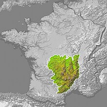
The geographic region of the Massif Central coincides with the geologic region with the same name. It is part of the Variscan orogenic cycle.[4] It was also a region of active volcanism during the Cenozoic.
References
- ^ Moores, Eldridge M., ed. (1997). Encyclopedia of European and Asian regional geology. London [u.a.]: Chapman & Hall. ISBN 978-0412740404.
- ^ a b Schmid, Stefan M.; Fügenschuh, Bernhard; Kissling, Eduard; Schuster, Ralf (30 April 2004). "Tectonic map and overall architecture of the Alpine orogen". Eclogae Geologicae Helvetiae. 97 (1): 93–117. doi:10.1007/s00015-004-1113-x.
- ^ Bousquet, Romain. "Tectonic framework of the Alps". Retrieved 26 February 2013.
- ^ Lardeaux, J.M; Ledru, P; Daniel, I; Duchene, S (28 February 2001). "The Variscan French Massif Central—a new addition to the ultra-high pressure metamorphic 'club': exhumation processes and geodynamic consequences" (PDF). Tectonophysics. 332 (1–2): 143–167. doi:10.1016/S0040-1951(00)00253-5. Retrieved 28 February 2013.
External links
Wikimedia Commons has media related to Geology of France.
- v
- t
- e
- Albania
- Andorra
- Armenia
- Austria
- Azerbaijan
- Belarus
- Belgium
- Bosnia and Herzegovina
- Bulgaria
- Croatia
- Cyprus
- Czech Republic
- Denmark
- Estonia
- Finland
- France
- Georgia
- Germany
- Greece
- Hungary
- Iceland
- Ireland
- Italy (Sicily)
- Kazakhstan
- Kosovo
- Latvia
- Liechtenstein
- Lithuania
- Luxembourg
- Malta
- Moldova
- Monaco
- Montenegro
- Netherlands
- North Macedonia
- Norway
- Poland
- Portugal
- Romania
- Russia
- San Marino
- Serbia
- Slovakia
- Slovenia
- Spain
- Sweden
- Switzerland
- Turkey
- Ukraine
- United Kingdom

- Aeolian Islands
- Aggtelek
- Calanques de Piana
- Curonian Spit
- Dolomites
- Durmitor
- Geirangerfjord
- Giant's Causeway
- Glarus
- High Coast
- Jungfrau-Aletsch
- Jurassic Coast
- Komi
- Kvarken
- Laponia
- Messel Pit
- Meteora
- Monte Perdido
- Monte San Giorgio
- Mount Etna
- Nærøyfjord
- Pirin
- Plitvice
- Rhine Gorge
- Scandola
- Škocjan
- St Kilda
- Stevns Klint
- Surtsey
- Thingvellir


