Freya Castle
Landform in the Grand Canyon, Arizona


Freya Castle

Freya Castle
Colorado Plateau
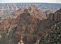
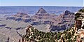
Freya Castle is a 7,288-foot-elevation (2,221-meter) summit located in the Grand Canyon, in Coconino County of northern Arizona, US.[3] It is situated one mile southeast of the Cape Royal overlook on the canyon's North Rim, 1.5 mile north of Vishnu Temple, and 1.7 mile northeast of Wotans Throne. Topographic relief is significant as it rises 3,400 feet (1,000 meters) above the Unkar Valley in one mile.
Freya Castle is named for Freya, the Norse goddess of love, beauty, fertility, sex, war, gold, and seiðr.[3] This name was applied by geologist François E. Matthes, in keeping with Clarence Dutton's practice of naming geographical features in the Grand Canyon after mythological deities.[4][5] This geographical feature's name was officially adopted in 1906 by the U.S. Board on Geographic Names.[3]
The first ascent of the summit was made by Harvey Butchart and Allyn Cureton on June 24, 1962.[6] According to the Köppen climate classification system, Freya Castle is located in a Cold semi-arid climate zone.[7]
Geology
The summit of Freya Castle is composed of cream-colored Permian Coconino Sandstone.[8] The sandstone, which is the third-youngest of the strata in the Grand Canyon, was deposited 265 million years ago as sand dunes. Below the Coconino Sandstone is soft, slope-forming, Permian Hermit Shale, which in turn overlays the Permian-Pennsylvanian- Supai Group. Further down are strata of Mississippian Redwall Limestone, Cambrian Tonto Group, and finally Proterozoic Unkar Group at creek level.[9] Precipitation runoff from Freya Castle drains south into the Colorado River via Vishnu Creek on its west side, and Unkar Creek on the east side.
Gallery
-
 Freya Castle centered, with Vishnu Temple to right, Apollo Temple distant left
 -
 Freya Castle front and center, with Vishnu Temple behind, as seen from Walhalla Overlook.
 -
 Freya Castle (left), Vishnu Temple (right)
 -
 View from northeast at Cape Final.
Left to right: Rama Shrine, Vishnu Temple, Freya Castle -
 summit detail
 -
 summit detail


See also
References
- ^ a b c "Freya Castle, Arizona". Peakbagger.com. Retrieved 2021-01-11.
- ^ a b c "Freya Castle – 7,288' AZ". Lists of John. Retrieved 2021-01-11.
- ^ a b c d "Freya Castle". Geographic Names Information System. United States Geological Survey, United States Department of the Interior. Retrieved 2021-01-11.
- ^ Stephen J. Pyne, Voyager: Seeking Newer Worlds in the Third Great Age of Discovery, 2010, Penguin Group.
- ^ Randy Moore and Kara Felicia Witt, The Grand Canyon: An Encyclopedia of Geography, History, and Culture, 2018, ABC-CLIO Publisher, p. 151.
- ^ "Harvey Butchart's Grand Canyon Hiking Logs". cholla.mmto.org. Retrieved 2021-01-11.
- ^ Peel, M. C.; Finlayson, B. L.; McMahon, T. A. (2007). "Updated world map of the Köppen−Geiger climate classification". Hydrol. Earth Syst. Sci. 11. ISSN 1027-5606.
- ^ N.H. Darton, Story of the Grand Canyon of Arizona, 1917, p. 58.
- ^ William Kenneth Hamblin, Anatomy of the Grand Canyon: Panoramas of the Canyon's Geology, 2008, Grand Canyon Association Publisher, ISBN 9781934656013
External links
Wikimedia Commons has media related to Freya Castle.


