Elizabeth Vale
Suburb of Adelaide, South Australia
| Elizabeth Vale Adelaide, South Australia | |||||||||||||||
|---|---|---|---|---|---|---|---|---|---|---|---|---|---|---|---|
 | |||||||||||||||
| Population | 4,331 (SAL 2021)[1] | ||||||||||||||
| Established | 1955 | ||||||||||||||
| Postcode(s) | 5112 | ||||||||||||||
| LGA(s) |
| ||||||||||||||
| State electorate(s) | Ramsay | ||||||||||||||
| Federal division(s) | Spence | ||||||||||||||
| |||||||||||||||
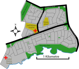
Elizabeth Vale is a suburb in the northern extent of Adelaide, South Australia. It was established in 1955.[citation needed] Its main roads are Main North Road to the east and John Rice Avenue which bisects the suburb. The southern boundary is the northern bank of the Little Para River.
Elizabeth Vale has two hospitals, the Lyell McEwin Hospital, a public teaching hospital, and the private Central Districts Hospital.
Demographics
The 2006 Census by the Australian Bureau of Statistics counted 3,667 persons in the suburb of Elizabeth Vale on census night. Of these, 1,766 (48.2%) were male and 1,901 (51.8%) were female.
The majority of residents 2,268 (61.7%) were Australian born, with 598 (16.3%) born in England.
The age distribution of Elizabeth Vale residents is similar to that of the greater Australian population. 69.8% of residents were aged 25 or over in 2006, compared to the Australian average of 66.5%; and 30.3% were younger than 25 years, compared to the Australian average of 33.5%.[2]
See also
References
- ^ Australian Bureau of Statistics (28 June 2022). "Elizabeth Vale (suburb and locality)". Australian Census 2021 QuickStats. Retrieved 28 June 2022.

- ^ "2006 Census QuickStats: Elizabeth Vale".
External links
- Playford Council
34°44′56″S 138°39′40″E / 34.749°S 138.661°E / -34.749; 138.661
- v
- t
- e
Suburbs of the City of Salisbury
- Bolivar
- Brahma Lodge
- Burton
- Cavan
- Direk
- Dry Creek
- Edinburgh
- Elizabeth Vale
- Globe Derby Park
- Green Fields
- Gulfview Heights
- Ingle Farm
- Mawson Lakes
- Para Hills
- Para Hills West
- Para Vista
- Parafield
- Parafield Gardens
- Paralowie
- Pooraka
- Salisbury
- Salisbury Downs
- Salisbury East
- Salisbury Heights
- Salisbury North
- Salisbury Park
- Salisbury Plain
- Salisbury South
- St Kilda
- Valley View
- Walkley Heights
- Waterloo Corner
 | This article about a place in Adelaide is a stub. You can help Wikipedia by expanding it. |
- v
- t
- e


