Donner Peak
Mountain in the state of California


Donner Peak
Location in California
Show map of California
Donner Peak
Donner Peak (the United States)
Show map of the United StatesDonner Peak is an 8,019-foot-elevation (2,444 meter) summit in Placer County, California, United States.
Description
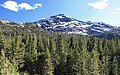
Donner Peak is located one mile southeast of Donner Pass, on land managed by Tahoe National Forest. It is situated in the Sierra Nevada mountain range, with precipitation runoff from the peak draining to Donner Lake. Topographic relief is modest as the summit rises 2,100 feet (640 meters) above Donner Lake in 1.5 mile. Neighbors include George R. Stewart Peak, one mile (1.6 km) to the north, and line parent Mount Judah, 0.73 miles (1.17 km) to the south.[3] The Pacific Crest Trail traverses the west slope of the peak, providing an approach from Donner Pass. Round-trip hiking distance to summit is 3.5 miles (5.6 km) with 940 feet (290 m) of elevation gain.[6]
History
This landform's toponym was officially adopted in October 1940 by the U.S. Board on Geographic Names, having appeared on an 1873 topographic map made by California Geological Survey.[5] The mountain was also called "Donner Peak" during 1865 construction of the route for the Central Pacific Railroad.[7] The railroad originally traversed the steep north cliffs of the peak via tunnels and snow sheds before the 10,322-foot-long (3,146 m) Tunnel #41 running under Mount Judah and Donner Peak was opened in 1925. The peak, pass, and lake are named for the ill-fated Donner Party who spent the winter of 1846–1847 snowbound at the east end of Donner Lake.[8]
Climate
According to the Köppen climate classification system, Donner Peak is located in an alpine climate zone.[9] Most weather fronts originate in the Pacific Ocean and travel east toward the Sierra Nevada mountains. As fronts approach, they are forced upward by the peaks (orographic lift), causing them to drop their moisture in the form of rain or snowfall onto the range. Donner Pass averages 51.6 inches (1,310 mm) of precipitation per year,[10] and with an average of 411.5 inches (10.45 m) of snow per year, it is one of the snowiest places in the contiguous United States.[11] There are five ski areas at Donner Pass.
Gallery
-
 North aspect of Donner Peak with railroad snowshed.
 -
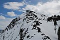 Summit of Donner Peak, from northwest
 -
 Donner Peak seen from McGlashan Point
 -
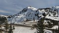
 North aspect
 -
 Donner Peak (centered) seen from Donner Lake, with parent Mount Judah partially visible behind, left.
 -
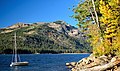
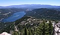
 Donner Lake (left) and Donner Peak (right)
 -
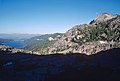
 The view of Donner Lake from Donner Peak
 -
 Mt. Judah (upper left), Donner Peak centered, from Donner Lake
 -
 Northeast aspect of Donner Peak rises above the west end of Donner Lake
 -
 The top of Donner Peak from Mount Judah Loop Trail
 -
 View east to Donner Lake, McGlashan Point, Donner Peak (right).
 -
 Donner Peak right of center


See also
 Mountains portal
- Donner Pass

References
- ^ United States Geological Survey topographical map - Norden
- ^ Matt Johanson (2021), California Summits, Falcon Guides, ISBN 9781493048175, p. 120
- ^ a b c "Donner Peak, California". Peakbagger.com. Retrieved 2022-07-04.
- ^ a b c "Donner Peak - 8,019' CA". listsofjohn.com. Retrieved 2022-07-04.
- ^ a b "Donner Peak". Geographic Names Information System. United States Geological Survey, United States Department of the Interior. Retrieved 2022-07-04.
- ^ Caroline Hinchliff (2020), Moon Drive & Hike Pacific Crest Trail, Avalon Publishing, ISBN 9781640492134
- ^ George Edward Gray (1865), Central Pacific Railroad of California: Report of George E. Gray Upon the Constructed Road and the Located Route, Made July 31, 1865, H.S. Crocker & Company, p. 7
- ^ Rickie Longfellow, The Hastings Cutoff and Highway 80 Tragedy of the Donner Party, fhwa.dot.gov
- ^ "Climate of the Sierra Nevada". Encyclopædia Britannica.
- ^ "Climate Summary of Donner Summit, California 1870–2001". Journal of the Sierra College Natural History Museum. 2 (1). Winter 2009. Archived from the original on 2013-02-24. Retrieved 2022-07-05.
- ^ "Donner Summit Snowfall and Snowpack 1879–2011". Central Sierra Snow Laboratory. University of California, Berkeley.
External links
- Donner Peak Rock Climbing: Mountainproject.com
- Donner Peak weather: Mountain-forecast.com


