Dead Horse Peak
Mountain in the American state of Utah


Dead Horse Peak
Location in Utah
Show map of Utah
Dead Horse Peak
Dead Horse Peak (the United States)
Show map of the United StatesRocky Mountains
Dead Horse Peak is a 12,642-foot elevation (3,853 m) mountain summit located on the common border that Duchesne County shares with Summit County in the U.S. state of Utah.
Description
Dead Horse Peak is set within the High Uintas Wilderness on land managed by Ashley National Forest and Uinta-Wasatch-Cache National Forest. It is situated along the crest of the Uinta Mountains which are a subset of the Rocky Mountains, and it ranks as the 50th-highest summit in Utah.[2] Topographic relief is significant as the southwest aspect rises 1,550 feet (470 meters) in less than one-half mile and the summit rises nearly 2,000 feet (610 meters) above Dead Horse Lake in one mile. Neighbors include Explorer Peak three miles to the southeast, Mount Beulah 3.5 miles north, and line parent Yard Peak is 1.5 mile northwest. Precipitation runoff from this mountain drains north to the Blacks Fork and south into headwaters of Rock Creek which is a tributary of the Duchesne River.
Etymology
This mountain's toponym has not been officially adopted by the United States Board on Geographic Names, so it is not labelled on USGS maps, and will remain unofficial as long as the USGS policy of not adopting new toponyms in designated wilderness areas remains in effect. The peak is named in association with Dead Horse Lake and Dead Horse Pass which are both one mile east of the peak, and are both officially named.[4][5]
Climate
Based on the Köppen climate classification, Dead Horse Peak is located in a subarctic climate zone with cold snowy winters and mild summers.[6] Tundra climate characterizes the summit and highest slopes.
Gallery
-
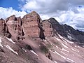 East aspect of Dead Horse Peak (shaded, right of center) seen from the trail between Dead Horse Lake and Dead Horse Pass
 -
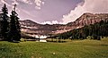
 Dead Horse Peak (left) with parent Yard Peak (right) from Allsop Lake
 -
 Dead Horse Peak (left), Allsop Lake, Yard Peak (right)
 -
 Dead Horse Lake as viewed from Dead Horse Pass
 -
 Dead Horse Peak (left) and Yard Peak (right of center) viewed from the north from airliner.


See also
- Geology of the Uinta Mountains
 Mountains portal

References
- ^ United States Geological Survey topographical map - Explorer Peak
- ^ a b c "Dead Horse Peak, Utah". Peakbagger.com. Retrieved 2022-08-07.
- ^ a b c "Dead Horse Peak - 12,642' UT". listsofjohn.com. Retrieved 2022-08-07.
- ^ "Dead Horse Lake". Geographic Names Information System. United States Geological Survey, United States Department of the Interior. Retrieved 2022-08-07.
- ^ "Dead Horse Pass". Geographic Names Information System. United States Geological Survey, United States Department of the Interior. Retrieved 2022-08-07.
- ^ Peel, M. C.; Finlayson, B. L. & McMahon, T. A. (2007). "Updated world map of the Köppen−Geiger climate classification". Hydrol. Earth Syst. Sci. 11 (5): 1633–1644. Bibcode:2007HESS...11.1633P. doi:10.5194/hess-11-1633-2007. ISSN 1027-5606. S2CID 9654551.
External links
- Utah's Highest Peaks, peakbagger.com


