Clach Biorach

Clach Chairidh, alternatively named Clach Biorach (from Scots Gaelic, meaning 'the Pointed Stone'), is a Class I Pictish stone located in a field near the village of Edderton in Easter Ross.
The standing stone was probably erected at some time in the Neolithic to Middle Bronze Age (4000 BC to 1500 BC), and Pictish symbols were later engraved at some time in the Late Iron Age to Early Medieval period (500 AD to 700 AD) on its north face. The symbols are a salmon above a double-disc with a Z-rod. When first recorded in 1780, a circle which is no longer visible was shown below on the left, which could have been part of a mirror. It is sandstone, 3.13m high, and at the base it has a width of 1.07m and depth of 0.46m.[1][2][3]
Gallery
-
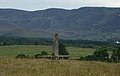 A distance photograph of Clach Biorach taken in July 2006.
 -
 The Pictish engravings in detail.


See also
- Celtic art
- Edderton Cross Slab
References
- v
- t
- e
Pictish sculptured stones
- Ackergill
- Birkle Hill
- Crosskirk
- Latheron
- Sandside
- Skinnet
- Ulbster
- Watenan
- Ardjachie Stone
- Dingwall Stone
- Edderton Cross Slab
- Clach Chairidh
- Gairloch Stone
- Hilton of Cadboll Stone
- Nigg Stone
- Poolewe Stone
- Portmahomack sculpture fragments
- Rosemarkie Stone
- Rosemarkie sculpture fragments
- Rosskeen Stone
- Shandwick Stone
- Strathpeffer Stone
- Advie Stone
- Ballintomb Stone
- Congash Stones
- Dunachton Stone
- Findlarig Stone
- Grantown Stone
- Inverallan Stone
- Lynchurn Stone
- Birnie Symbol Stone
- Burghead Bulls
- Burghead (fragment) stone
- Dandaleith stone
- Drainie Carved Stones
- Easterton of Roseisle stone
- Elgin Pillar
- Inveravon Church stones (4)
- Rodney's Stone
- Sculptor's Cave symbol wall carvings
- Sueno's Stone
- Balbair Stones
- Culaird Stone
- Dores Stone
- Drumbuie Stone
- Garbeg Stone
- Invereen Stone
- Kingsmills Stone
- Knocknagael Stone
- Lochardill Stone
- Torgorm Stone
- Ardlair Stone
- Aquhollie Stone
- Brandsbutt Stone
- Broomend of Crichie stone
- Cairnton stone
- Dunnicaer stones
- Dyce stones
- Fordoun Stone
- Fyvie Stones
- Kintore stones
- Logie Elphinstone Stones
- Maiden Stone
- Migvie Stone
- Monymusk Stone
- Nether Corskie Stone
- Newbigging, Leslie Stone
- Newton Stone
- Picardy Stone
- Rhynie Stones
- Tillytarmont Stones
- Abdie stone
- Scoonie Stone
- Brough of Birsay
- Greens
- Knowe of Burrian
- Breck of Hillwell
- Cunningsburgh
57°50′13″N 4°10′33″W / 57.83694°N 4.17583°W / 57.83694; -4.17583
 | This article about a Scottish building or structure is a stub. You can help Wikipedia by expanding it. |
- v
- t
- e
 | This article relating to archaeology in the United Kingdom is a stub. You can help Wikipedia by expanding it. |
- v
- t
- e


