Ciofrângeni
Commune in Argeș, Romania
(2020–2024) (2021-12-01)[1]
117250
Ciofrângeni is a commune in Argeș County, Muntenia, Romania. It is composed of five villages: Burluși, Ciofrângeni, Lacurile, Piatra, and Schitu-Matei.
The commune lies in the Wallachian Plain, on the banks of the Topolog River. It is located in the western part of Argeș County, 43 km (27 mi) northwest of the county seat, Pitești, on the border with Vâlcea County.
Ciofrângeni is crossed by the national road DN73C [ro], which starts in Câmpulung, runs through Curtea de Argeș (16 km (9.9 mi) to the east), and ends in Râmnicu Vâlcea (21 km (13 mi) to the west).
References
- ^ "Populaţia rezidentă după grupa de vârstă, pe județe și municipii, orașe, comune, la 1 decembrie 2021" (XLS). National Institute of Statistics.
-
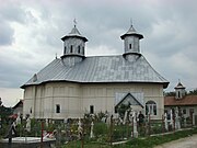 Church in Ciofrângeni village
 -
 Church in Lacurile village
 -
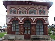
 Church in Schitu-Matei village
 -
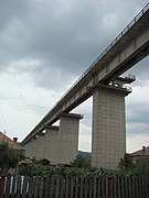 The Topolog Viaduct in Ciofrângeni


- v
- t
- e
Argeș County, Romania
- Pitești (county seat)
- Câmpulung
- Curtea de Argeș

- Albeștii de Argeș
- Albeștii de Muscel
- Albota
- Aninoasa
- Arefu
- Băbana
- Băiculești
- Bălilești
- Bârla
- Bascov
- Beleți-Negrești
- Berevoești
- Bogați
- Boteni
- Boțești
- Bradu
- Brăduleț
- Budeasa
- Bughea de Jos
- Bughea de Sus
- Buzoești
- Căldăraru
- Călinești
- Căteasca
- Cepari
- Cetățeni
- Cicănești
- Ciofrângeni
- Ciomăgești
- Cocu
- Corbeni
- Corbi
- Coșești
- Cotmeana
- Cuca
- Dâmbovicioara
- Dârmănești
- Davidești
- Dobrești
- Domnești
- Drăganu
- Dragoslavele
- Godeni
- Hârsești
- Hârtiești
- Izvoru
- Leordeni
- Lerești
- Lunca Corbului
- Mălureni
- Mărăcineni
- Merișani
- Micești
- Mihăești
- Mioarele
- Miroși
- Morărești
- Moșoaia
- Mozăceni
- Mușătești
- Negrași
- Nucșoara
- Oarja
- Pietroșani
- Poiana Lacului
- Poienarii de Argeș
- Poienarii de Muscel
- Popești
- Priboieni
- Râca
- Rătești
- Recea
- Rociu
- Rucăr
- Sălătrucu
- Săpata
- Schitu Golești
- Slobozia
- Stâlpeni
- Ștefan cel Mare
- Stoenești
- Stolnici
- Șuici
- Suseni
- Teiu
- Tigveni
- Țițești
- Uda
- Ungheni
- Valea Danului
- Valea Iașului
- Valea Mare-Pravăț
- Vedea
- Vlădești
- Vulturești
 | This Argeș County location article is a stub. You can help Wikipedia by expanding it. |
- v
- t
- e


