Boulevard Heights, St. Louis
Neighborhood of St. Louis in Missouri, United States
Boulevard Heights | |
|---|---|
Neighborhood of St. Louis | |
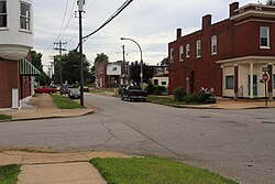 Boulevard Heights, July 2016 | |
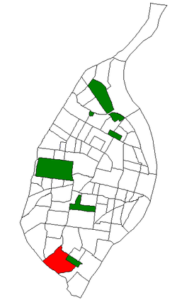 Location (red) of Boulevard Heights within St. Louis | |
| Country | United States |
| State | Missouri |
| City | St. Louis |
| Wards | 11, 12, 13 |
| Area | |
| • Total | 1.52 sq mi (3.9 km2) |
| Population (2020)[1] | |
| • Total | 8,690 |
| • Density | 5,700/sq mi (2,200/km2) |
| ZIP code(s) | Part of 63116 |
| Area code(s) | 314 |
| Website | stlouis-mo.gov |
Boulevard Heights is a neighborhood of St. Louis, Missouri. The neighborhood is bounded by Gravois Avenue on the west, Holly Hills Boulevard and Carondelet Park on the north, South Grand Avenue and I-55 on the east, and the city limits on the south.
History
Early history
Much of the land within the neighborhood was previously known as Morganford, and land to the east of Morganford Road was part of the Carondelet Commons. The area began to be settled by Americans and German immigrants in the 1870s, though most of the area was not residential until after World War II.[2]
Churches
Boulevard Heights is home to numerous churches that have played important roles in the neighborhood throughout its history. Founded in 1905, the St. Lucas Evangelical Lutheran Church on Morganford Road was the first Slovak Lutheran Church west of the Mississippi. Other churches in the neighborhood include the Immaculate Heart of Mary Catholic Church, the Foursquare Church, and the Christy Park Baptist Church.[2]
Demographics
| Census | Pop. | Note | %± |
|---|---|---|---|
| 1990 | 9,226 | — | |
| 2000 | 8,969 | −2.8% | |
| 2010 | 8,708 | −2.9% | |
| 2020 | 8,690 | −0.2% | |
| Sources:[3] | |||
In 2020 Boulevard Heights' racial makeup was 74.0% White, 6.4% Black, 0.3% Native American, 9.1% Asian, 7.9% Two Or More Races, and 2.2% Some Other Race. 5.5% of the population was of Hispanic or Latino origin.[4]
References
- v
- t
- e
- Academy
- Baden
- Benton Park
- Benton Park West
- Bevo Mill
- Botanical Heights
- Boulevard Heights
- Carondelet
- Carr Square
- Central West End
- Cheltenham
- Chinatown (defunct since 1966)
- Clayton/Tamm
- Clifton Heights
- College Hill
- Columbus Square
- Compton Heights
- Covenant Blu Grand Center
- DeBaliviere Place
- "Dogtown"
- Downtown
- Downtown West
- Dutchtown
- Ellendale
- Fairground
- Forest Park Southeast
- Fountain Park
- Fox Park
- Franz Park
- Gate District
- Gravois Park
- Greater Ville
- Hamilton Heights
- The Hill
- Hi-Pointe
- Holly Hills
- Hyde Park
- JeffVanderLou
- Kings Oak
- Kingsway East
- Kingsway West
- Kosciusko
- Lafayette Square
- LaSalle Park
- Lewis Place
- Lindenwood Park
- Marine Villa
- Mark Twain
- Mark Twain/I-70 Industrial
- McKinley Heights
- Midtown
- Mill Creek Valley (defunct since 1960s)
- Mount Pleasant
- Near North Riverfront
- Northampton
- North Point
- North Riverfront
- O'Fallon
- Old North St. Louis
- Patch
- Peabody–Darst–Webbe
- Penrose
- Princeton Heights
- Riverview
- Shaw
- Skinker DeBaliviere
- Soulard
- Southampton
- Southwest Garden
- St. Louis Hills
- St. Louis Place
- Tiffany
- Tower Grove East
- Tower Grove South
- Vandeventer
- The Ville
- Visitation Park
- Walnut Park East
- Walnut Park West
- Wells/Goodfellow
- West End
- Wydown/Skinker
38°33′35″N 90°17′07″W / 38.5598°N 90.2854°W / 38.5598; -90.2854
 | This St. Louis location article is a stub. You can help Wikipedia by expanding it. |
- v
- t
- e


