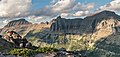
Bishops Cap


Bishops Cap
Location in Montana
Show map of Montana
Bishops Cap
Location in the United States
Show map of the United StatesMontana, US
Bishops Cap (9,127 feet (2,782 m)) is located in the Lewis Range, Glacier National Park in the U.S. state of Montana.[4] Located above the Garden Wall and straddling the Continental Divide, when viewed from the south at Logan Pass, the peak appears to resemble a Bishop's headwear. The name Bishops Cap is descriptive only, and there's no known origin.[5]
Geology
Like other mountains in Glacier National Park, Bishops Cap is composed of sedimentary rock laid down during the Precambrian to Jurassic periods. Formed in shallow seas, this sedimentary rock was initially uplifted beginning 170 million years ago when the Lewis Overthrust fault pushed an enormous slab of precambrian rocks 3 mi (4.8 km) thick, 50 miles (80 km) wide and 160 miles (260 km) long over younger rock of the cretaceous period.[6]
Climate
According to the Köppen climate classification system, Bishops Cap is located in an alpine subarctic climate zone with long, cold, snowy winters, and cool to warm summers.[7] Winter temperatures can drop below −10 °F with wind chill factors below −30 °F. Due to its altitude, it receives precipitation all year, as snow in winter, and as thunderstorms in summer.
Gallery
-
 Mt. Gould (left), Bishops Cap (center), Pollock Mountain (right) from Mt. Oberlin
 -
 Bishops Cap (centered) with Haystack Butte to the right, from the northwest.
 -
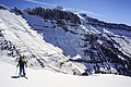 Bishops Cap (centered) seen from Haystack Butte


See also
- Mountains and mountain ranges of Glacier National Park (U.S.)
References
- ^ a b "Bishops Cap, Montana". Peakbagger.com. Retrieved June 4, 2018.
- ^ a b "Bishops Cap - 9,127' MT". listsofjohn.com. Retrieved 2021-11-05.
- ^ "Bishops Cap". Geographic Names Information System. United States Geological Survey, United States Department of the Interior. Retrieved June 4, 2018.
- ^ Logan Pass, MT (Map). TopoQwest (United States Geological Survey Maps). Retrieved June 4, 2018.
- ^ Holterman, Jack (2006). Place Names of Glacier National Park. Helena, MT: Riverbend Publishing. p. 34. ISBN 1-931832-68-4.
- ^ Gadd, Ben (2008). "Geology of the Rocky Mountains and Columbias".
{{cite journal}}: Cite journal requires|journal=(help) - ^ Peel, M. C.; Finlayson, B. L.; McMahon, T. A. (2007). "Updated world map of the Köppen−Geiger climate classification". Hydrol. Earth Syst. Sci. 11. ISSN 1027-5606.
| Authority control databases: National |
|
|---|
- v
- t
- e
 | This Glacier County, Montana state location article is a stub. You can help Wikipedia by expanding it. |
- v
- t
- e


