Bellows Falls Neighborhood Historic District
Historic district in Vermont, United States
United States historic place
Bellows Falls Neighborhood Historic District | |
 Old YMCA, Bellows Falls | |
43°7′53″N 72°26′57″W / 43.13139°N 72.44917°W / 43.13139; -72.44917 | |
| Area | 42.3 acres (17.1 ha) (original) 8.8 acres (3.6 ha) (increase) |
|---|---|
| Built by | Multiple |
| Architect | Buckman (20 South St.) |
| Architectural style | Federal, Greek Revival |
| NRHP reference No. | 01001477[1] (original) 07000403 (increase) |
| Significant dates | |
| Added to NRHP | January 17, 2002 |
| Boundary increase | May 4, 2007 |
The Bellows Falls Neighborhood Historic District encompasses a residential area of the village of Bellows Falls, Vermont. Located south of downtown Bellows Falls, the area has one of the largest concentrations of well-preserved 19th century residences in southern Vermont. It was listed on the National Register of Historic Places in 2002, and enlarged in 2007.[1]
Description and history
Bellows Falls is an incorporated village within the municipality of Rockingham in southeastern Vermont. It is located on the west bank of the Connecticut River, and was the site at which that river was first bridged, in 1785. As a consequence, the village has since then been a transportation hub, as a nexus of water, road, and railroad routes formed there over the course of the 19th century. Industrial development grew in part due to the Bellows Falls Canal, which provided water power to a variety of industries. The village downtown grew immediately west of the canal and the primary industrial area, and its residential neighborhoods grew west and south of the downtown.[2]
The residential historic district, when first designated in 2002, was a roughly 42-acre (17 ha) bounded on the north by School Street, the east by Westminster Street, and the west by Atkinson Street (United States Route 5), extending a short way west of Atkinson on Burt Street and Hapgood Place.[2] In 2007 it was enlarged by about 9 acres (3.6 ha) to the southwest, extending that boundary south of Burt Street to Pine and Center Streets, and Old Terrace to the southeast.[3]
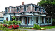
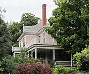
This neighborhood area contains one of the best concentrations of pre-World War II residential architecture in southern Vermont. Most of the housing in this area is wood-frame construction, buildings typically containing one to three units. Most of the housing stock was built between about 1850 and 1920, when the village was economically at its peak, and represent a cross section of architectural styles of that period. The oldest buildings in the area date to the late 18th century. Institutional buildings include two schools, two churches, two fraternal meeting houses, a library, and a funeral home. More than 90% of the buildings in the district were built before 1950, a remarkably high concentration for districts of this size.[2]
- Bellows Falls Neighborhood Historic District
-
![The Bellows Falls Masonic Temple, formerly the Wyman & Almira Flint House, was built c.1870 in the Second Empire style[4] (2017)](//upload.wikimedia.org/wikipedia/commons/thumb/a/ac/Masonic_Temple%2C_Bellows_Falls_Vermont.jpg/187px-Masonic_Temple%2C_Bellows_Falls_Vermont.jpg) The Bellows Falls Masonic Temple, formerly the Wyman & Almira Flint House, was built c.1870 in the Second Empire style[4]
The Bellows Falls Masonic Temple, formerly the Wyman & Almira Flint House, was built c.1870 in the Second Empire style[4]
(2017) -
 A Victorian house at 6 Temple Street
(2017) -
 The William A. Hall House was built in 1890–92 in the Colonial Revival stye. It is now the Readmore Inn.
(2013) -
![The Rockingham Free Public Library, built in 1909, is a Carnegie library[4] (2017)](//upload.wikimedia.org/wikipedia/commons/thumb/8/89/Rockingham_Public_Library%2C_Bellows_Falls%2C_Vermont.jpg/187px-Rockingham_Public_Library%2C_Bellows_Falls%2C_Vermont.jpg) The Rockingham Free Public Library, built in 1909, is a Carnegie library[4]
The Rockingham Free Public Library, built in 1909, is a Carnegie library[4]
(2017) -
![The former armory of Company E of the First Infantry of the Vermont National Guard was built in 1915. It is now low-income housing.[4] (2017)](//upload.wikimedia.org/wikipedia/commons/thumb/9/95/Former_Armory%2C_Company_E_First_Infantry_Vemont_National_Guard%2C_Bellows_Falls%2C_Vermont.jpg/187px-Former_Armory%2C_Company_E_First_Infantry_Vemont_National_Guard%2C_Bellows_Falls%2C_Vermont.jpg) The former armory of Company E of the First Infantry of the Vermont National Guard was built in 1915. It is now low-income housing.[4]
The former armory of Company E of the First Infantry of the Vermont National Guard was built in 1915. It is now low-income housing.[4]
(2017)
![The Bellows Falls Masonic Temple, formerly the Wyman & Almira Flint House, was built c.1870 in the Second Empire style[4] (2017)](http://upload.wikimedia.org/wikipedia/commons/thumb/a/ac/Masonic_Temple%2C_Bellows_Falls_Vermont.jpg/187px-Masonic_Temple%2C_Bellows_Falls_Vermont.jpg)


![The Rockingham Free Public Library, built in 1909, is a Carnegie library[4] (2017)](http://upload.wikimedia.org/wikipedia/commons/thumb/8/89/Rockingham_Public_Library%2C_Bellows_Falls%2C_Vermont.jpg/187px-Rockingham_Public_Library%2C_Bellows_Falls%2C_Vermont.jpg)
![The former armory of Company E of the First Infantry of the Vermont National Guard was built in 1915. It is now low-income housing.[4] (2017)](http://upload.wikimedia.org/wikipedia/commons/thumb/9/95/Former_Armory%2C_Company_E_First_Infantry_Vemont_National_Guard%2C_Bellows_Falls%2C_Vermont.jpg/187px-Former_Armory%2C_Company_E_First_Infantry_Vemont_National_Guard%2C_Bellows_Falls%2C_Vermont.jpg)
See also
References
- ^ a b "National Register Information System". National Register of Historic Places. National Park Service. July 9, 2010.
- ^ a b c "NRHP nomination for Bellows Falls Neighborhood Historic District". National Park Service. Retrieved November 10, 2015.
- ^ "NRHP nomination for Bellows Falls Residential Historic District (2007 increase)". National Park Service. Retrieved November 10, 2015.
- ^ a b c ""Bellows Falls Neighborhood Historic District Self-Guided Walking Tour"" (PDF). Archived from the original (PDF) on October 20, 2016. Retrieved July 22, 2018.
- v
- t
- e
Historic
Landmarks
- Naulakha
- Rockingham Meetinghouse

- Bellows Falls Downtown Historic District
- Bellows Falls Neighborhood Historic District
- Brattleboro Downtown Historic District
- Canal Street–Clark Street Neighborhood Historic District
- Crows Nest
- Dickinson Estate Historic District
- Follett Stone Arch Bridge Historic District
- George–Pine–Henry Street Historic District
- Grafton Village Historic District
- Homestead–Horton Neighborhood Historic District
- Houghtonville Historic District
- Mechanicsville Historic District
- Middletown Rural Historic District
- Moore and Thompson Paper Mill Complex
- Newfane Village Historic District
- Parker Hill Rural Historic District ‡
- Putney Village Historic District
- Rockingham Village Historic District
- Saxtons River Village Historic District
- Scott Farm Historic District
- Samuel Gilbert Smith Farmstead
- South Londonderry Village Historic District
- South Windham Village Historic District
- Stratton Mountain Lookout Tower
- Townshend State Park
- Vermont Academy Campus Historic District
- West Brattleboro Green Historic District
- West Dover Village Historic District
- West Townshend Village Historic District
- Westminster Terrace Historic District
- Westminster Village Historic District
- Whitingham Village Historic District
- Williams Street Extension Historic District
- Wilmington Village Historic District
- Windham Village Historic District
| Commercial | |
|---|---|
| Educational/ Health |
|
| Government |
|
| Industrial | |
| Religious |
|
| Residential |
|
| Transportation |
|
- Bartonsville Covered Bridge
- Bridge 19
- Creamery Covered Bridge
- East Putney Brook Stone Arch Bridge
- Green River Covered Bridge
- Green River Crib Dam
- Hall Covered Bridge
- Kidder Covered Bridge
- Medburyville Bridge
- Rice Farm Road Bridge
- Sacketts Brook Stone Arch Bridge
- Scott Covered Bridge
- Simpsonville Stone Arch Bridge
- South Newfane Bridge
- West Dummerston Covered Bridge
- West Townshend Stone Arch Bridge
- Williams River Route 5 Bridge
- Williamsville Covered Bridge
- Worrall Covered Bridge
‡ This historic property also has portions in an adjacent county.


