Aust Severn Powerline Crossing
Power line span over the River Severn in Great Britain

Aust Severn Powerline Crossing is the longest overhead power line span in the United Kingdom with a length of 1,618 m (5,308 ft).[1]
History
The crossing spans the River Severn between Aust and Beachley and is part of the National Grid.
It was commissioned in 1959,[2] and comprises two 275 kV electricity circuits, which form part of the 275 kV Iron Acton to Whitson line.[3]

Construction
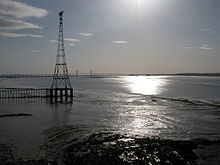
It is situated south of the Severn Bridge and was built by J. L. Eve Construction, which became Eve Group, and is now Babcock Networks. It is mounted on two pylons, each 148.75 m (488.0 ft) tall. The pylon on the Aust side of the River Severn stands on a caisson accessible via a small bridge.

Map all coordinates using OpenStreetMap
Download coordinates as:
- KML
- GPX (all coordinates)
- GPX (primary coordinates)
- GPX (secondary coordinates)
| Point | Coordinates (links to map & photo sources) | Notes |
|---|---|---|
| Aust pylon | 51°36′09″N 2°38′00″W / 51.6026°N 2.6332°W / 51.6026; -2.6332 (Aust pylon) | |
| Mid-point | 51°36′21″N 2°38′29″W / 51.60578°N 2.64136°W / 51.60578; -2.64136 (Mid-point) | |
| Beachley pylon | 51°36′37″N 2°39′11″W / 51.6102°N 2.6531°W / 51.6102; -2.6531 (Beachley pylon) |
See also
- List of spans
- Powerline river crossings in the United Kingdom
- Crossings of the River Severn
- Crossings of the River Wye
- Severn-Wye Cable Tunnel
References
Wikimedia Commons has media related to Severn powerline crossing.
- ^ "Electricity pylons". GLIAS. Archived from the original on 10 March 2007. Retrieved 2 April 2007.
- ^ Electricity Council (1987). Electricity supply in the United Kingdom: a chronology. London: Electricity Council. pp. 77–8. ISBN 085188105X.
- ^ "Open Infrastructure Map". Open Infrastructure Map. Retrieved 20 March 2020.
- v
- t
- e
National Grid
- 275 kV Forth Crossing
- 400 kV Thames Crossing
- Aust Severn Powerline Crossing
- Blackhillock Substation
- BritNed
- Fawley Tunnel
- Gridlink Interconnector
- Huddersfield Narrow Canal Pylon
- HVDC Cross-Channel
- HVDC Kingsnorth (dismantled)
- Severn-Wye Cable Tunnel
51°36′21″N 2°38′29″W / 51.60578°N 2.64136°W / 51.60578; -2.64136 (Aust Severn Powerline Crossing - nominal location)


