Štrbački buk
Waterfall
| Štrbački buk | |
|---|---|
| Штрбачки бyк | |
 | |
 | |
| Elevation | 296 metres (971 ft) |
| Total height | 25 metres (82 ft) |
| Watercourse | Una River |
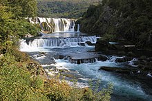
Štrbački buk (Serbian Cyrillic: Штрбачки бyк) waterfall is a 25m high waterfall on the Una River (296m altitude). It is situated in Croatia and Bosnia and Herzegovina (Una-Sana Canton, city Bihać, settlement Doljani and Celije).[1]
It is the highest waterfall in Una National Park,[2] and Lonely Planet described it as "A strong contender for the title of the nation's most impressive waterfall".[3]
References
Wikimedia Commons has media related to Štrbački buk.
- v
- t
- e
Hydrography of Bosnia and Herzegovina
| Danube/Black Sea watershed |
|
|---|---|
| Adriatic watershed |
|

| Mountain lakes (natural/glacial) | |
|---|---|
| Ponds (natural & artificial) |
|
| Artificial reservoirs |
canyons
- Bioštica
- Bistrica (Drina)
- Bregava
- Doljanka
- Drežnica
- Drina
- Drinjača
- Krivaja
- Lim
- Miljacka
- Misoča
- Mostarska Bijela
- Neretva
- Neretvica
- Piva
- Prača
- Rakitnica (Neretva)
- Sana
- Čude Canyon & Stupčanica
- Sutjeska
- Sutjeska
- Tara River Canyon
- Ugar
- Una
- Unac
- Upper Neretva
- Vrbas
- Željeznica
- Žepa
- Sava marshes
- Bardača
- Hutovo Blato
- Mostarsko Blato
- Bliha
- Bobaš
- Čeveljuša
- Dušćica falls
- Ilomska falls
- Koćuša
- Kozica
- Kravica
- Marina Pećina falls
- Una falls
- Pliva
- Skakavac (Sarajevo)
- Skakavac (Perućica)
- Skakavac (Duboka)
- Štrbački buk
- Ugar falls
- Vrbanja falls
- Ždrimački slap
 Lakes portal ♦
  Rivers portal ♦
  Wetlands portal ♦ List of rivers of Bosnia and Herzegovina ♦ List of lakes of Bosnia and Herzegovina ♦ List of karst springs in Bosnia and Herzegovina
Hydrography of Croatia | ||||||
|---|---|---|---|---|---|---|
| Rivers |
|  | ||||
| Lakes | ||||||
| Valleys, estuaries, canyons, wetlands | ||||||
| Waterfalls |
| |||||
| Canals |
| |||||
| Adriatic Sea | ||||||
44°39′28″N 16°00′17″E / 44.657765°N 16.00467°E / 44.657765; 16.00467
 | This Lika-Senj County geography article is a stub. You can help Wikipedia by expanding it. |
- v
- t
- e
 | This Una-Sana Canton geography article is a stub. You can help Wikipedia by expanding it. |
- v
- t
- e


