Liste von Inseln in der Shark Bay
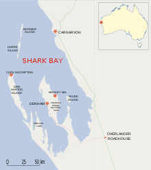
In der Liste der Inseln in der Shark Bay befinden sich etwa 30 Inseln, die in der Shark Bay im Indischen Ozean, etwa 800 Kilometer nördlich von Perth, im Bundesstaat Western Australia liegen.
Alle etwa 30 Inseln liegen in einem Gebiet, das im Jahr 1991 von der UNESCO in die Liste des Welterbes eingetragen worden ist.[1] Innerhalb dieses UNESCO-Schutzgebietes gibt es weitere Schutzgebiete, die für die Inseln große Bedeutung haben.
In der Bucht ist das Dirk Hartog Island mit 630 km² die größte Insel, es folgen das 60 km² große Dorre Island, das 58 km² große Faure Island, das 45 km² große Bernier Island und lediglich Salutation Island erreicht mit 1,7 km² eine Größe von über 1 km². Alle anderen sind unter 1 km² groß.[2]
Liste der Inseln in der Shark Bay (alphabetisch):
- Ant Island
- Babbage Island
- Baudin Island
- Bernier Island, 45 km²
- Boora Island
- Charles Island
- Dirk Hartog Island, 630 km²
- Dorre Island, 60 km²
- Double Island
- Eagle Island
- Egg Island
- Faure Island, 58 km²
- Freycinet Island
- Friday Island
- Hutchison Islands
- Kangaroo Island
- Koks Island
- Lefebre Island
- Mary Anne Island
- Meade Island
- North Guano Island
- North Kangaroo Island
- Parrot Island
- Pelican Island
- Salutation Island, 1,7 km²
- Slope Island
- Smith Islands
- South Guano Island
- Sunday Island
- Three Bays Island
- White Island
- Whitlock Island
- Wilds Island
- Wilson Island
Weblinks
- Liste australischer Inseln
Einzelnachweise
- ↑ Shark Bay, Western Australia, von 1991. In: UNESCO
- ↑ Shark Bay World Heritage Property, Environmental values, Cultural uses and potential Petroleum Industry impacts. In: Department of Environmental Protection. 1. Juli 2001, archiviert vom Original am 12. November 2009; abgerufen am 23. August 2010.


